
Greer County topographic map
Interactive map
Click on the map to display elevation.
About this map
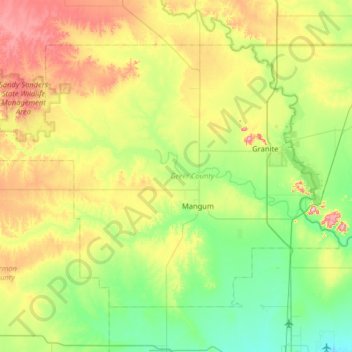
Name: Greer County topographic map, elevation, terrain.
Location: Greer County, Oklahoma, United States of America (34.72463 -99.88827 35.11698 -99.24667)
Average elevation: 504 m
Minimum elevation: 411 m
Maximum elevation: 705 m
Other topographic maps
Click on a map to view its topography, its elevation and its terrain.
Skiatook Lake
United States of America > Oklahoma > Morgans Corner
Skiatook Lake, Major General Clarence L. Tinker Memorial Highway, Morgans Corner, Osage County, Oklahoma, United States of America
Average elevation: 228 m
Porum
United States of America > Oklahoma > Porum
Porum, Muskogee County, Oklahoma, 74455, United States of America
Average elevation: 181 m
Idabel
United States of America > Oklahoma > Idabel
Idabel, McCurtain County, Oklahoma, 74745, United States of America
Average elevation: 132 m
Woodall
United States of America > Oklahoma
Woodall, Cherokee County, Oklahoma, United States of America
Average elevation: 232 m
Guymon
United States of America > Oklahoma > Guymon
Guymon, Texas, Oklahoma, United States of America
Average elevation: 933 m
Coalgate
United States of America > Oklahoma > Coalgate
Coalgate, Coal County, Oklahoma, 74538, United States of America
Average elevation: 186 m
Foss
United States of America > Oklahoma > Foss
Foss, Washita County, Oklahoma, United States of America
Average elevation: 508 m
Wynnewood
United States of America > Oklahoma > Wynnewood
Wynnewood, Oklahoma, 73098, United States of America
Average elevation: 271 m
Bethany
United States of America > Oklahoma > Bethany
Bethany, Oklahoma County, Oklahoma, United States of America
Average elevation: 396 m