
Ancient and Primeval Beech Forests of the Carpathians and Other Regions of Europe topographic map
Interactive map
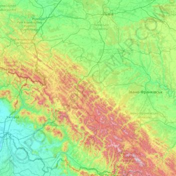
Click on the map to display elevation.
About this map
Name: Ancient and Primeval Beech Forests of the Carpathians and Other Regions of Europe topographic map, elevation, terrain.
Average elevation: 467 m
Minimum elevation: 98 m
Maximum elevation: 2,008 m
Other topographic maps
Click on a map to view its topography, its elevation and its terrain.
Hoverla
In the 20th century, the mountain increasingly gained popularity as an extreme sports site. Some routes are classified as 1A in the winter period (from late autumn to May), according to the Soviet grading system. The most popular approach to the summit starts from the tour-basa Zarosliak on the mountain's…
Average elevation: 1,667 m