
Make a donation
Gear up for your next adventure:
As an Amazon Associate, this site earns from qualifying purchases at no extra cost to you.
Gangavathi topographic map
Click on the map to display elevation.
Make a donation
Gear up for your next adventure:
As an Amazon Associate, this site earns from qualifying purchases at no extra cost to you.
Gangavathi
Gangavathi lies at an average elevation of 406 metres (1,332 ft), and is situated close to the Tungabhadra Dam. It is a taluka (administrative division) of Koppal, a district that was previously part of Raichur.
Make a donation
Gear up for your next adventure:
As an Amazon Associate, this site earns from qualifying purchases at no extra cost to you.
About this map
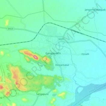
Name: Gangavathi topographic map, elevation, terrain.
Location: Gangavathi, Gangavati taluku, Koppal, Karnataka, 583227, India (15.38611 76.49067 15.46611 76.57067)
Average elevation: 421 m
Minimum elevation: 384 m
Maximum elevation: 588 m
Make a donation
Gear up for your next adventure:
As an Amazon Associate, this site earns from qualifying purchases at no extra cost to you.