Geolocate

Pinjore topographic map

Click on the map to display elevation.

About this map

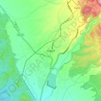
Name: Pinjore topographic map, elevation, terrain.

Location: Pinjore, Kalka, Panchkula, Haryana, 134102, India (30.76424 76.87495 30.84424 76.95495)

Average elevation: 554 m

Minimum elevation: 397 m

Maximum elevation: 930 m

Gear up for your next adventure:

🗺️Ordnance Survey Maps - Essential paper maps for hiking across the UK national parks
❄️Walking Crampons - Added traction for icy slopes and winter peak bagging
🧭Emergency Beacons - Safety beacons for remote outdoor locations
🧦Hiking Socks - Breathable socks designed to prevent blisters on long walks
GPS Outdoor Watches - Watches with GPS tracking for hiking and exploration

As an Amazon Associate, this site earns from qualifying purchases at no extra cost to you.