
Make a donation
Gear up for your next adventure:
As an Amazon Associate, this site earns from qualifying purchases at no extra cost to you.
Gaggiolo topographic map
Click on the map to display elevation.
Make a donation
Gear up for your next adventure:
As an Amazon Associate, this site earns from qualifying purchases at no extra cost to you.
About this map
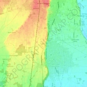
Name: Gaggiolo topographic map, elevation, terrain.
Location: Gaggiolo, Bellinzago Novarese, Novara, Piedmont, 28043, Italy (45.55878 8.61536 45.59878 8.65536)
Average elevation: 211 m
Minimum elevation: 183 m
Maximum elevation: 244 m
Make a donation
Gear up for your next adventure:
As an Amazon Associate, this site earns from qualifying purchases at no extra cost to you.
Other topographic maps
Click on a map to view its topography, its elevation and its terrain.
Ameno
The municipal area is located on a large plateau overlooking the eastern shore of Lake Orta. The village is surrounded by coppiced woods and is a popular destination for summer holidays with numerous houses located along the road running between the mountain and the lake. The territory has an elevation ranging…
Average elevation: 468 m
Make a donation
Gear up for your next adventure:
As an Amazon Associate, this site earns from qualifying purchases at no extra cost to you.
Make a donation
Gear up for your next adventure:
As an Amazon Associate, this site earns from qualifying purchases at no extra cost to you.
Make a donation
Gear up for your next adventure:
As an Amazon Associate, this site earns from qualifying purchases at no extra cost to you.
Make a donation
Gear up for your next adventure:
As an Amazon Associate, this site earns from qualifying purchases at no extra cost to you.