
Make a donation
Gear up for your next adventure:
As an Amazon Associate, this site earns from qualifying purchases at no extra cost to you.
Spin Wam topographic map
Click on the map to display elevation.
Make a donation
Gear up for your next adventure:
As an Amazon Associate, this site earns from qualifying purchases at no extra cost to you.
About this map
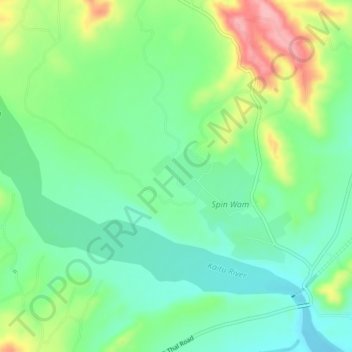
Name: Spin Wam topographic map, elevation, terrain.
Average elevation: 755 m
Minimum elevation: 712 m
Maximum elevation: 839 m
Make a donation
Gear up for your next adventure:
As an Amazon Associate, this site earns from qualifying purchases at no extra cost to you.
Other topographic maps
Click on a map to view its topography, its elevation and its terrain.
Khyber Pakhtunkhwa
Most precipitation falls as thunderstorms or snow during winter and spring, so that the climate at the lowest elevations is classed as Mediterranean (Csa), continental Mediterranean (Dsa) or semi-arid (BSk). Summers are extremely dry in the north of Chitral district and receive only a little rain in the south…
Average elevation: 2,135 m
Make a donation
Gear up for your next adventure:
As an Amazon Associate, this site earns from qualifying purchases at no extra cost to you.
Make a donation
Gear up for your next adventure:
As an Amazon Associate, this site earns from qualifying purchases at no extra cost to you.
Abbottabad
Pakistan > Khyber Pakhtunkhwa > Abbottābād District
Abbottabad is a city in the Hazara Division of Khyber Pakhtunkhwa province, Pakistan. It is the 40th largest city in the country and 6th largest in the province by population, and serves as the headquarter of its namesake tehsil and district. It is about 120 km (75 mi) north of Islamabad-Rawalpindi and 150 km…
Average elevation: 1,363 m
Make a donation
Gear up for your next adventure:
As an Amazon Associate, this site earns from qualifying purchases at no extra cost to you.
Dera Ismail Khan
Pakistan > Khyber Pakhtunkhwa > Dera Ismail Khan District
D. I Khan is situated at an altitude of 177 metres above sea level.
Average elevation: 177 m
Make a donation
Gear up for your next adventure:
As an Amazon Associate, this site earns from qualifying purchases at no extra cost to you.
Make a donation
Gear up for your next adventure:
As an Amazon Associate, this site earns from qualifying purchases at no extra cost to you.
Make a donation
Gear up for your next adventure:
As an Amazon Associate, this site earns from qualifying purchases at no extra cost to you.
Make a donation
Gear up for your next adventure:
As an Amazon Associate, this site earns from qualifying purchases at no extra cost to you.
Make a donation
Gear up for your next adventure:
As an Amazon Associate, this site earns from qualifying purchases at no extra cost to you.
Zargirandeh
Pakistan > Khyber Pakhtunkhwa > Chitrāl District > Chitral Tehsil
Average elevation: 2,043 m
Dir
Pakistan > Khyber Pakhtunkhwa > Upper Dir District
The topography of Upper Dir is dominated by high mountains. The most important mountain range is the Hindu Kush. It runs from north east to south west along the northern borders with Chitral District. In winter whole area remains snow-covered. The mountains in the western part of the district are covered with…
Average elevation: 2,204 m
Make a donation
Gear up for your next adventure:
As an Amazon Associate, this site earns from qualifying purchases at no extra cost to you.
Mullazai
Pakistan > Khyber Pakhtunkhwa > Peshāwar District > Peshawar City Tehsil
Average elevation: 347 m
Kohat
Pakistan > Khyber Pakhtunkhwa > Kohat District
Kohat city is located at an altitude of 489 metres (1,604 ft). Kohat Pass lies to the north. It is situated on the left bank of the Toi river at a point where after running nearly due east for 50 miles (80 km), it turns to the south. The total area of the district is 2,545 square kilometres (983 sq mi)
Average elevation: 722 m
Upper Gazikistan Glacier
Pakistan > Khyber Pakhtunkhwa > Chitrāl District > Chitral Tehsil
Average elevation: 5,086 m
Make a donation
Gear up for your next adventure:
As an Amazon Associate, this site earns from qualifying purchases at no extra cost to you.
Chitral
Pakistan > Khyber Pakhtunkhwa > Chitrāl District
The city has an average elevation of 1,500 m (4,921 ft).
Average elevation: 2,982 m
Dir
Pakistan > Khyber Pakhtunkhwa > Upper Dir District
The topography of Upper Dir is dominated by high mountains. The most important mountain range is the Hindu Kush. It runs from north east to south west along the northern borders with Chitral District. In winter whole area remains snow-covered. The mountains in the western part of the district are covered with…
Average elevation: 2,204 m
Kohat
Pakistan > Khyber Pakhtunkhwa > Kohat District
Kohat city is located at an altitude of 489 metres (1,604 ft). Kohat Pass lies to the north. It is situated on the left bank of the Toi river at a point where after running nearly due east for 50 miles (80 km), it turns to the south. The total area of the district is 2,545 square kilometres (983 sq mi)
Average elevation: 722 m
Make a donation
Gear up for your next adventure:
As an Amazon Associate, this site earns from qualifying purchases at no extra cost to you.
Make a donation
Gear up for your next adventure:
As an Amazon Associate, this site earns from qualifying purchases at no extra cost to you.
Make a donation
Gear up for your next adventure:
As an Amazon Associate, this site earns from qualifying purchases at no extra cost to you.
Make a donation
Gear up for your next adventure:
As an Amazon Associate, this site earns from qualifying purchases at no extra cost to you.
Cherat
Pakistan > Khyber Pakhtunkhwa > Nowshera District
Cherat (Pashto: چېراټ) is a hill station dating from the 1860s that is located immediately above the villages of Chapri,Bakhti, Saleh Khana, Kotli Kalan and Dak Ismail Khel in the Nowshera District of Khyber-Pakhtunkhwa in Pakistan. Cherat lies 34 miles south east from the city of Peshawar at an elevation…
Average elevation: 986 m
Make a donation
Gear up for your next adventure:
As an Amazon Associate, this site earns from qualifying purchases at no extra cost to you.
Daggar
Pakistan > Khyber Pakhtunkhwa > Buner District
Daggar (Pashto: ډاګر, Urdu: ڈگر) or Dagar is the capital of Buner District in the Khyber-Pakhtunkhwa province of Pakistan. It is located at 34°30′41″N 72°29′02″E / 34.51139°N 72.48389°E / 34.51139; 72.48389 and has an average elevation of 688 metres (2260 feet). Daggar is also an…
Average elevation: 793 m
Orakzai District
Orakzai Agency is a hilly region with a fertile valley. The elevation of the hills varies from over 10,000 feet (3,000 m) in the west and to less than 6,650 feet (2,030 m) in east. Generally, the elevation of the plain varies from 5,200 to 5,500 feet (1,700 m) above sea level. Important peaks are Sangla (6325…
Average elevation: 1,512 m
Make a donation
Gear up for your next adventure:
As an Amazon Associate, this site earns from qualifying purchases at no extra cost to you.
Chitral
Pakistan > Khyber Pakhtunkhwa > Chitrāl District
The city has an average elevation of 1,500 m (4,921 ft).
Average elevation: 2,982 m
Lora Tehsil
Pakistan > Khyber Pakhtunkhwa > Abbottābād District
Lora is located at an altitude of 1148 metres (3769 feet). It is situated in the southern part of Abbottabad District formerly part of Havelian Tehsil, it is now the headquarters of Lora Tehsil. It is bounded by the following union councils, Nara to the north, Nagri Totial to the north and east, Goreeni to the…
Average elevation: 1,359 m
Orakzai District
Orakzai Agency is a hilly region with a fertile valley. The elevation of the hills varies from over 10,000 feet (3,000 m) in the west and to less than 6,650 feet (2,030 m) in east. Generally, the elevation of the plain varies from 5,200 to 5,500 feet (1,700 m) above sea level. Important peaks are Sangla (6325…
Average elevation: 1,512 m
Make a donation
Gear up for your next adventure:
As an Amazon Associate, this site earns from qualifying purchases at no extra cost to you.
Dir
Pakistan > Khyber Pakhtunkhwa > Upper Dir District
The topography of Upper Dir is dominated by high mountains. The most important mountain range is the Hindu Kush. It runs from north east to south west along the northern borders with Chitral District. In winter whole area remains snow-covered. The mountains in the western part of the district are covered with…
Average elevation: 2,204 m
Drosh
Pakistan > Khyber Pakhtunkhwa > Chitrāl District
Drosh is low elevation and is a large village in Chitral District on the traditional trade route to Drosh-Jalalabad Road. Drosh is located on 35° 33' 33" N and 71° 47' 44" E on the banks of the Landai Sin River (Bashgal River) just above its intersection with the Kunar River (Chitral River), along the…
Average elevation: 1,851 m
Make a donation
Gear up for your next adventure:
As an Amazon Associate, this site earns from qualifying purchases at no extra cost to you.
Charsadda
Pakistan > Khyber Pakhtunkhwa > Charsadda District
Chārsadda (Pashto: چارسده; pronounce; Urdu: چارسدہ; pronounce) is a town and headquarters of Charsadda District, in the Khyber Pakhtunkhwa province of Pakistan. It is the 85th-largest city of Pakistan, according to 2017 census. Located in the Valley of Peshawar, Charsadda lies about 29 kilometres…
Average elevation: 317 m
Swat District
The average elevation of Swat is 980 m (3,220 ft), resulting in a considerably cooler and wetter climate compared to the rest of Pakistan. With lush forests, verdant alpine meadows, and snow-capped mountains, Swat is one of the country's most popular tourist destinations.
Average elevation: 2,674 m
Peshawar Cantonment
Pakistan > Khyber Pakhtunkhwa > Peshāwar District > Peshawar City Tehsil
Average elevation: 352 m
Make a donation
Gear up for your next adventure:
As an Amazon Associate, this site earns from qualifying purchases at no extra cost to you.
Junali Kuch
Pakistan > Khyber Pakhtunkhwa > Chitrāl District > Torkhow-Molkhow Tehsil
Average elevation: 2,198 m
Make a donation
Gear up for your next adventure:
As an Amazon Associate, this site earns from qualifying purchases at no extra cost to you.
Abbottabad
Pakistan > Khyber Pakhtunkhwa > Abbottābād District
Abbottabad is a city in the Hazara Division of Khyber Pakhtunkhwa province, Pakistan. It is the 40th largest city in the country and 6th largest in the province by population, and serves as the headquarter of its namesake tehsil and district. It is about 120 km (75 mi) north of Islamabad-Rawalpindi and 150 km…
Average elevation: 1,363 m
Peshawar Cantonment
Pakistan > Khyber Pakhtunkhwa > Peshāwar District > Peshawar City Tehsil
Average elevation: 352 m
Make a donation
Gear up for your next adventure:
As an Amazon Associate, this site earns from qualifying purchases at no extra cost to you.
Make a donation
Gear up for your next adventure:
As an Amazon Associate, this site earns from qualifying purchases at no extra cost to you.
Tirich Mir
Pakistan > Khyber Pakhtunkhwa > Chitrāl District > Torkhow-Molkhow Tehsil
The weather station 4,245 m (13,927 ft) above sea level lies in the Tundra climate/Alpine climate (ET) zone according to Köppen Climate Classification. On this specific altitude (4,245 m or 13,927 ft asl) we find moderately cold winters and cool summers generally above freezing. Annual mean temperature is…
Average elevation: 6,802 m
Make a donation
Gear up for your next adventure:
As an Amazon Associate, this site earns from qualifying purchases at no extra cost to you.
Battagram
Pakistan > Khyber Pakhtunkhwa > Battagram District
Battagram (Urdu: بٹگرام, Pashto: بټګرام) is a city and Union Council of Battagram District in Khyber Pakhtunkhwa Province of Pakistan. It is located at 34°41'N 73°1'E and has an altitude of 1038 metres (3408 feet).
Average elevation: 1,316 m
Make a donation
Gear up for your next adventure:
As an Amazon Associate, this site earns from qualifying purchases at no extra cost to you.
Make a donation
Gear up for your next adventure:
As an Amazon Associate, this site earns from qualifying purchases at no extra cost to you.