
Selsey topographic map
Click on the map to display elevation.
Selsey
A study published by Princeton University and McGill University, in 2020, concluded that the Manhood Peninsula is at particularly high risk of flooding as its topography is less than 5 metres (16 ft) above the current mean sea level and that by 2100 Selsey will be subject to permanent inundation.
About this map
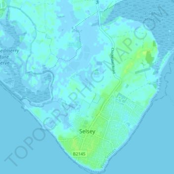
Name: Selsey topographic map, elevation, terrain.
Location: Selsey, Chichester, West Sussex, England, United Kingdom (50.72178 -0.81895 50.76629 -0.74938)
Average elevation: 1 m
Minimum elevation: -4 m
Maximum elevation: 9 m
West Sussex trails, hiking, mountain biking, running and outdoor activities
Other topographic maps
Click on a map to view its topography, its elevation and its terrain.
Donnington Park
United Kingdom > England > West Sussex > Chichester > Donnington
Average elevation: 8 m
Horncroft Common Plantation
United Kingdom > England > West Sussex > Chichester
Average elevation: 22 m
Blackdown
United Kingdom > England > West Sussex > Chichester
Blackdown, or Black Down, summit elevation 279.7 metres (918 ft) AMSL, is the highest point in both the historic county of Sussex and the South Downs National Park. It is one of the highest points in the south east of England, exceeded by Walbury Hill, Leith Hill and Pilot Hill. Blackdown is protected as part…
Average elevation: 165 m