
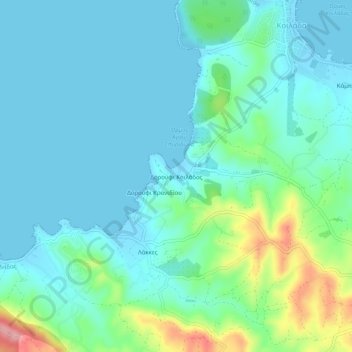
Δορούφι Κοιλάδος topographic map
Interactive map
Click on the map to display elevation.
About this map
Name: Δορούφι Κοιλάδος topographic map, elevation, terrain.
Average elevation: 30 m
Minimum elevation: -2 m
Maximum elevation: 149 m
Other topographic maps
Click on a map to view its topography, its elevation and its terrain.
Petrothalassa
Greece > Peloponnese, Western Greece and the Ionian > Argolis Regional Unit > Municipal Unit of Kranidi
Average elevation: 24 m
Portocheli
Greece > Peloponnese, Western Greece and the Ionian > Argolis Regional Unit > Municipal Unit of Kranidi
Average elevation: 19 m
Kranidi
Greece > Peloponnese, Western Greece and the Ionian > Argolis Regional Unit > Municipal Unit of Kranidi
Average elevation: 77 m