
Rincón de Vargas topographic map
Interactive map
Click on the map to display elevation.
About this map
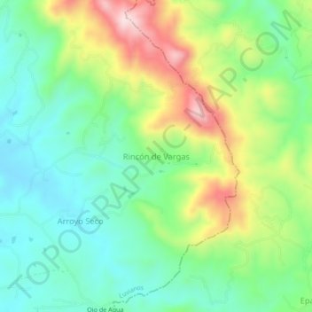
Name: Rincón de Vargas topographic map, elevation, terrain.
Location: Rincón de Vargas, Luvianos, État de Mexico, Mexique (18.92120 -100.26417 18.96120 -100.22417)
Average elevation: 1,261 m
Minimum elevation: 1,130 m
Maximum elevation: 1,510 m
Other topographic maps
Click on a map to view its topography, its elevation and its terrain.
Plan de Chihuahua
Mexique > État de Mexico > Luvianos
Plan de Chihuahua, Luvianos, État de Mexico, Mexique
Average elevation: 1,236 m