
Gwonseon-gu topographic map
Interactive map
Click on the map to display elevation.
About this map
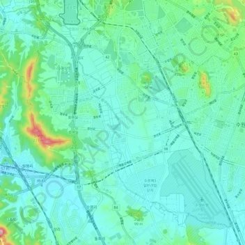
Name: Gwonseon-gu topographic map, elevation, terrain.
Location: Gwonseon-gu, Suwon-si, Gyeonggi, South Korea (37.22453 126.92697 37.30331 127.04216)
Average elevation: 47 m
Minimum elevation: 8 m
Maximum elevation: 237 m
Other topographic maps
Click on a map to view its topography, its elevation and its terrain.