
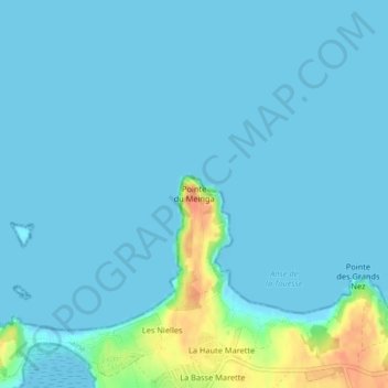
Pointe du Meinga topographic map
Interactive map
Click on the map to display elevation.
About this map
Name: Pointe du Meinga topographic map, elevation, terrain.
Average elevation: 6 m
Minimum elevation: -2 m
Maximum elevation: 45 m
Other topographic maps
Click on a map to view its topography, its elevation and its terrain.
Plage du Havre
France > Bretagne > Saint-Coulomb
Plage du Havre, Boulevard de Rothéneuf, La Sablière, Saint-Coulomb, Saint-Malo, Ille-et-Vilaine, Bretagne, France métropolitaine, 35350, France
Average elevation: 15 m
Les Coutillons
France > Bretagne > Saint-Coulomb > Les Coutillons
Les Coutillons, Saint-Coulomb, Saint-Malo, Ille-et-Vilaine, Bretagne, France métropolitaine, 35350, France
Average elevation: 12 m
Plage du Guesclin
France > Bretagne > Saint-Coulomb
Plage du Guesclin, D 201, La Petite Croix, La Ville Hernier, Saint-Coulomb, Saint-Malo, Ille-et-Vilaine, Bretagne, France métropolitaine, 35350, France
Average elevation: 16 m
Île du Guesclin
France > Bretagne > Saint-Coulomb
Île du Guesclin, Saint-Coulomb, Saint-Malo, Ille-et-Vilaine, Bretagne, France métropolitaine, 35350, France
Average elevation: 10 m
Fort du Guesclin
France > Bretagne > Saint-Coulomb > La Basse Ville-Enoux
Fort du Guesclin, D 201, La Basse Ville-Enoux, Saint-Coulomb, Saint-Malo, Ille-et-Vilaine, Bretagne, France métropolitaine, 35260, France
Average elevation: 11 m
Anse du Guesclin
France > Bretagne > Saint-Coulomb
Anse du Guesclin, D 201, La Petite Croix, La Ville Hernier, Saint-Coulomb, Saint-Malo, Ille-et-Vilaine, Bretagne, France métropolitaine, 35350, France
Average elevation: 15 m