Geolocate

Ha Maliau topographic map

Interactive map

Click on the map to display elevation.

About this map

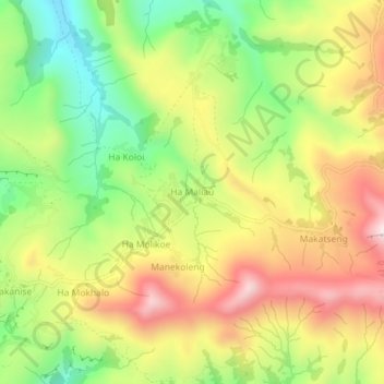
Name: Ha Maliau topographic map, elevation, terrain.

Location: Ha Maliau, Quthing District, Lesotho (-30.39571 27.74998 -30.35571 27.78998)

Average elevation: 1,810 m

Minimum elevation: 1,542 m

Maximum elevation: 2,099 m

Other topographic maps

Click on a map to view its topography, its elevation and its terrain.

Moeling

Lesotho > Quthing District

Moeling, Quthing District, Lesotho

Average elevation: 1,786 m

Moyeni (Quthing)

Lesotho > Quthing District > Moyeni (Quthing)

Moyeni (Quthing), Quthing District, Lesotho

Average elevation: 1,644 m