
Make a donation
Gear up for your next adventure:
As an Amazon Associate, this site earns from qualifying purchases at no extra cost to you.
Mornago topographic map
Click on the map to display elevation.
Make a donation
Gear up for your next adventure:
As an Amazon Associate, this site earns from qualifying purchases at no extra cost to you.
About this map
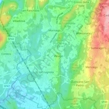
Name: Mornago topographic map, elevation, terrain.
Location: Mornago, Varese, Lombardy, Italy (45.71057 8.72355 45.76175 8.78056)
Average elevation: 308 m
Minimum elevation: 256 m
Maximum elevation: 433 m
Make a donation
Gear up for your next adventure:
As an Amazon Associate, this site earns from qualifying purchases at no extra cost to you.
Other topographic maps
Click on a map to view its topography, its elevation and its terrain.
Castendallo
Italy > Lombardy > Varese > Montegrino Valtravaglia > Bosco Valtravaglia
Average elevation: 491 m
Make a donation
Gear up for your next adventure:
As an Amazon Associate, this site earns from qualifying purchases at no extra cost to you.
Make a donation
Gear up for your next adventure:
As an Amazon Associate, this site earns from qualifying purchases at no extra cost to you.