Lakpa topographic map
Interactive map
Click on the map to display elevation.
About this map
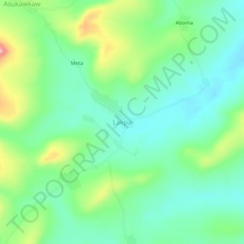
Name: Lakpa topographic map, elevation, terrain.
Location: Lakpa, Okere District, Eastern Region, Ghana (6.06948 -0.19479 6.10948 -0.15479)
Average elevation: 191 m
Minimum elevation: 132 m
Maximum elevation: 328 m
Other topographic maps
Click on a map to view its topography, its elevation and its terrain.
Apirede
Ghana > Eastern Region > Okere District
Apirede, Okere District, Eastern Region, Ghana
Average elevation: 342 m
Adukrom
Ghana > Eastern Region > Okere District
Adukrom, Okere District, Eastern Region, Ghana
Average elevation: 304 m