
Make a donation
Gear up for your next adventure:
As an Amazon Associate, this site earns from qualifying purchases at no extra cost to you.
Granville topographic map
Click on the map to display elevation.
Make a donation
Gear up for your next adventure:
As an Amazon Associate, this site earns from qualifying purchases at no extra cost to you.
About this map
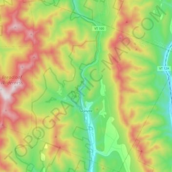
Name: Granville topographic map, elevation, terrain.
Location: Granville, Addison County, Vermont, 05747, United States (43.93609 -72.91224 44.07366 -72.74224)
Average elevation: 616 m
Minimum elevation: 243 m
Maximum elevation: 1,151 m
Make a donation
Gear up for your next adventure:
As an Amazon Associate, this site earns from qualifying purchases at no extra cost to you.
Other topographic maps
Click on a map to view its topography, its elevation and its terrain.
Abbey Pond Cascades (lower)
United States > Vermont > Addison County > Middlebury
Average elevation: 305 m
Make a donation
Gear up for your next adventure:
As an Amazon Associate, this site earns from qualifying purchases at no extra cost to you.
Lake Dunmore
United States > Vermont > Addison County > Salisbury > Lake Dunmore
Average elevation: 192 m
Make a donation
Gear up for your next adventure:
As an Amazon Associate, this site earns from qualifying purchases at no extra cost to you.