
Make a donation
Gear up for your next adventure:
As an Amazon Associate, this site earns from qualifying purchases at no extra cost to you.
Wadi Rum desert topographic map
Click on the map to display elevation.
Make a donation
Gear up for your next adventure:
As an Amazon Associate, this site earns from qualifying purchases at no extra cost to you.
Wadi Rum desert
The area is centered on the main valley of Wadi Rum. The highest elevation in Jordan is Jabal Umm ad Dami at 1,840 m (6,040 ft) high (SRTM data states 1854 m), located 30 kilometres south of Wadi Rum village. It was first located by Difallah Ateeg, a Zalabia Bedouin from Rum. On a clear day, it is possible to see the Red Sea and the Saudi border from the top.
Make a donation
Gear up for your next adventure:
As an Amazon Associate, this site earns from qualifying purchases at no extra cost to you.
About this map
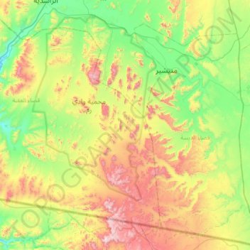
Name: Wadi Rum desert topographic map, elevation, terrain.
Average elevation: 1,041 m
Minimum elevation: 637 m
Maximum elevation: 1,831 m
Make a donation
Gear up for your next adventure:
As an Amazon Associate, this site earns from qualifying purchases at no extra cost to you.