Geolocate

Sablayan topographic map

Click on the map to display elevation.

About this map

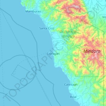
Name: Sablayan topographic map, elevation, terrain.

Location: Sablayan, Occidental Mindoro, Mimaropa, 5104, Philippines (12.52132 120.27303 13.17816 121.24399)

Average elevation: 239 m

Minimum elevation: 0 m

Maximum elevation: 2,543 m

Other topographic maps

Click on a map to view its topography, its elevation and its terrain.

Rizal

Philippines > Occidental Mindoro > Rizal

Average elevation: 4 m

Gear up for your next adventure:

🪢Paracord - Multi-purpose cord for camping and survival
🕶️Glacier Goggles - Maximum protection for high-altitude snow topography
🔦Keychain LED Torches - Emergency backup light for finding gear in your pack
🧭Professional Hiking Compasses - High-precision liquid-filled compasses for map reading and orientation
🧵Survival Paracord - Multi-purpose cordage for emergency repairs and shelters

As an Amazon Associate, this site earns from qualifying purchases at no extra cost to you.