
Lengnau topographic map
Interactive map
Click on the map to display elevation.
About this map
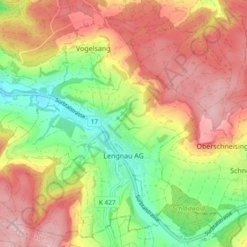
Name: Lengnau topographic map, elevation, terrain.
Location: Lengnau, Bezirk Zurzach, Aargau, 5426, Schweiz (47.50626 8.28894 47.54736 8.35493)
Average elevation: 512 m
Minimum elevation: 393 m
Maximum elevation: 624 m
Other topographic maps
Click on a map to view its topography, its elevation and its terrain.
Tegerfelden
Schweiz > Aargau > Bezirk Zurzach
Tegerfelden, Bezirk Zurzach, Aargau, 5306, Schweiz
Average elevation: 436 m
Hörndli
Schweiz > Aargau > Bezirk Zurzach > Zurzach
Hörndli, Zurzach, Bezirk Zurzach, Aargau, 5330, Schweiz
Average elevation: 402 m
Bad Zurzach
Schweiz > Aargau > Bezirk Zurzach > Zurzach
Bad Zurzach, Zurzach, Bezirk Zurzach, Aargau, 5330, Schweiz
Average elevation: 394 m
Siglistorf
Schweiz > Aargau > Bezirk Zurzach
Siglistorf, Bezirk Zurzach, Aargau, 5462, Schweiz
Average elevation: 534 m