
Make a donation
Gear up for your next adventure:
As an Amazon Associate, this site earns from qualifying purchases at no extra cost to you.
Bear Cross topographic map
Click on the map to display elevation.
Make a donation
Gear up for your next adventure:
As an Amazon Associate, this site earns from qualifying purchases at no extra cost to you.
About this map
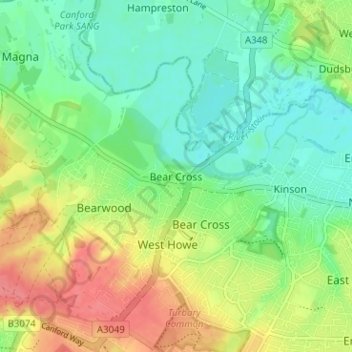
Name: Bear Cross topographic map, elevation, terrain.
Average elevation: 30 m
Minimum elevation: 5 m
Maximum elevation: 68 m
Bournemouth, Christchurch and Poole trails, hiking, mountain biking, running and outdoor activities
Make a donation
Gear up for your next adventure:
As an Amazon Associate, this site earns from qualifying purchases at no extra cost to you.
Other topographic maps
Click on a map to view its topography, its elevation and its terrain.
Redhill Park
United Kingdom > England > Bournemouth, Christchurch and Poole > Bournemouth > Talbot Village
Average elevation: 33 m
Kings Park
United Kingdom > England > Bournemouth, Christchurch and Poole > Bournemouth
Average elevation: 31 m