
Tegalsari topographic map
Interactive map
Click on the map to display elevation.
About this map
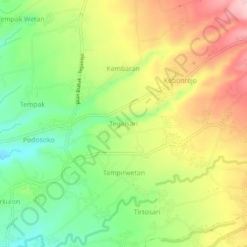
Name: Tegalsari topographic map, elevation, terrain.
Location: Tegalsari, Magelang, Central Java, 56512, Indonesia (-7.54625 110.25540 -7.50625 110.29540)
Average elevation: 400 m
Minimum elevation: 308 m
Maximum elevation: 504 m
Other topographic maps
Click on a map to view its topography, its elevation and its terrain.
Lapangan Paripurno Kecamatan Salaman
Indonesia > Central Java > Magelang > Kembanglimus
Average elevation: 276 m