
Old Forge topographic map
Interactive map
Click on the map to display elevation.
About this map
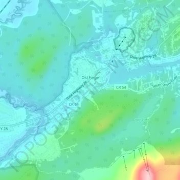
Name: Old Forge topographic map, elevation, terrain.
Average elevation: 543 m
Minimum elevation: 509 m
Maximum elevation: 702 m
Other topographic maps
Click on a map to view its topography, its elevation and its terrain.
Stratford
United States > New York > Herkimer County
Stratford, Town of Salisbury, Herkimer County, New York, 13470, United States
Average elevation: 359 m
City of Little Falls
United States > New York > Herkimer County
City of Little Falls, Town of Little Falls, Herkimer County, New York, 13365, United States
Average elevation: 223 m
Town of Manheim
United States > New York > Herkimer County
Town of Manheim, Town of Little Falls, Herkimer County, New York, United States
Average elevation: 246 m
Harbor
United States > New York > Herkimer County > Harbor
Harbor, Town of Frankfort, Herkimer County, New York, 13504, United States
Average elevation: 156 m
Bull Hill
United States > New York > Herkimer County > Bull Hill
Bull Hill, Town of Ohio, Herkimer County, New York, United States
Average elevation: 421 m
Manheim Center
United States > New York > Herkimer County > Manheim Center
Manheim Center, Town of Manheim, Herkimer County, New York, United States
Average elevation: 196 m
Kast Bridge
United States > New York > Herkimer County > Kast Bridge
Kast Bridge, Town of Herkimer, Herkimer County, New York, 13350, United States
Average elevation: 218 m
Eagle Bay
United States > New York > Herkimer County > Eagle Bay
Eagle Bay, Town of Webb, Herkimer County, New York, 13360, United States
Average elevation: 551 m