Geolocate

Town of Manlius topographic map

Interactive map

Click on the map to display elevation.

About this map

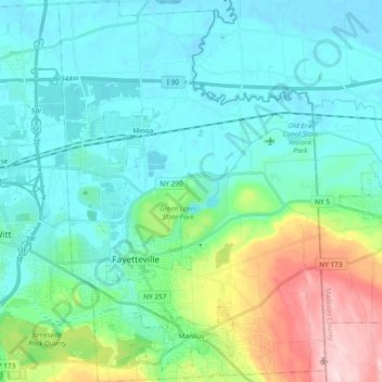
Name: Town of Manlius topographic map, elevation, terrain.

Location: Town of Manlius, Onondaga County, New York, United States (42.98525 -76.04249 43.12305 -75.91045)

Average elevation: 179 m

Minimum elevation: 115 m

Maximum elevation: 415 m

Other topographic maps

Click on a map to view its topography, its elevation and its terrain.

Town of Cicero

United States > New York > Onondaga County

Town of Cicero, Onondaga County, New York, United States

Average elevation: 120 m

City of Syracuse

United States > New York > Onondaga County

City of Syracuse, Onondaga County, New York, United States

Average elevation: 172 m

Hiawatha Lake

United States > New York > Onondaga County > City of Syracuse

Hiawatha Lake, Strathmore, City of Syracuse, Onondaga County, New York, United States

Average elevation: 151 m

Town of Clay

United States > New York > Onondaga County

Town of Clay, Onondaga County, New York, United States

Average elevation: 120 m

Camillus

United States > New York > Onondaga County > Camillus

Camillus, Onondaga County, New York, United States

Average elevation: 177 m

Pompey

United States > New York > Onondaga County > Town of Pompey > Pompey

Pompey, Town of Pompey, Onondaga County, New York, 13138, United States

Average elevation: 450 m

Apulia

United States > New York > Onondaga County > Town of Fabius > Apulia

Apulia, Town of Fabius, Onondaga County, New York, 13020, United States

Average elevation: 409 m