
Temple topographic map
Interactive map
Click on the map to display elevation.
Temple
Terrain is generally uneven and rocky. It is also elevated, commanding distant views to the east and south. As John Farmer and Jacob Bailey Moore wrote in 1823, "From the highest point of elevation, twenty meetinghouses may be seen when the atmosphere is clear."
About this map
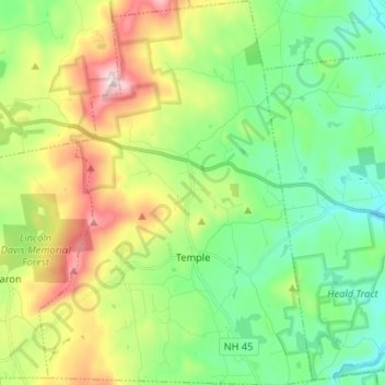
Name: Temple topographic map, elevation, terrain.
Average elevation: 346 m
Minimum elevation: 175 m
Maximum elevation: 685 m
Other topographic maps
Click on a map to view its topography, its elevation and its terrain.
South Uncanoonuc Mountain
United States > New Hampshire > Hillsborough County > Goffstown
Average elevation: 243 m
Souhegan River
United States > New Hampshire > Hillsborough County > Milford > East Milford
Average elevation: 84 m
Piscataquog River
United States > New Hampshire > Hillsborough County > Manchester
Average elevation: 59 m
Souhegan River Watershed Dam Number 35
United States > New Hampshire > Hillsborough County > New Ipswich > Smithville
Average elevation: 349 m
West Peterborough
United States > New Hampshire > Hillsborough County > Peterborough
Average elevation: 299 m
Hillsboro Lower Village
United States > New Hampshire > Hillsborough County > Hillsborough
Average elevation: 242 m
Campbell Mountain
United States > New Hampshire > Hillsborough County > Hillsborough
Average elevation: 338 m
Massachusetts Drive Park
United States > New Hampshire > Hillsborough County > Nashua
Average elevation: 48 m
Souhegan River
United States > New Hampshire > Hillsborough County > Milford > East Milford
Average elevation: 84 m
North Brookline
United States > New Hampshire > Hillsborough County > Brookline > North Brookline
Average elevation: 124 m
North Village
United States > New Hampshire > Hillsborough County > Peterborough
Average elevation: 251 m
Nakuru Lake
United States > New Hampshire > Hillsborough County > Hudson > Hudson Center
Average elevation: 80 m
South Weare
United States > New Hampshire > Hillsborough County > Weare > South Weare
Average elevation: 210 m