
Hyde Hall topographic map
Interactive map
Click on the map to display elevation.
About this map
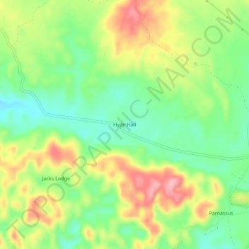
Name: Hyde Hall topographic map, elevation, terrain.
Location: Hyde Hall, Trelawny, Cornwall County, Jamaica (18.41045 -77.58897 18.45045 -77.54897)
Average elevation: 210 m
Minimum elevation: 149 m
Maximum elevation: 290 m
Other topographic maps
Click on a map to view its topography, its elevation and its terrain.