
Villa Nueva City topographic map
Interactive map
Click on the map to display elevation.
About this map
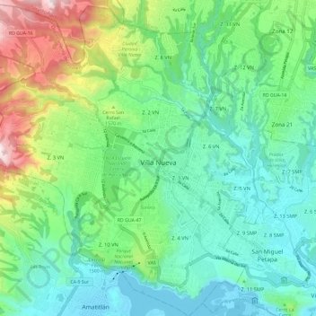
Name: Villa Nueva City topographic map, elevation, terrain.
Location: Villa Nueva City, Guatemala Department, 01064, Guatemala (14.47582 -90.66364 14.58891 -90.55123)
Average elevation: 1,433 m
Minimum elevation: 1,188 m
Maximum elevation: 2,096 m
Other topographic maps
Click on a map to view its topography, its elevation and its terrain.
Guatemala City
Guatemala > Guatemala Department > Guatemala City > Guatemala City
Average elevation: 1,558 m