
Yerupajá topographic map
Interactive map
Click on the map to display elevation.
About this map
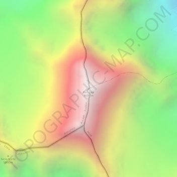
Name: Yerupajá topographic map, elevation, terrain.
Location: Yerupajá, Pacllón, Province of Bolognesi, Ancash, Peru (-10.26867 -76.90561 -10.26857 -76.90551)
Average elevation: 5,637 m
Minimum elevation: 4,698 m
Maximum elevation: 6,506 m
Based on the elevation provided by the available Digital elevation models, SRTM2 (6558m with voids), SRTM filled with ASTER (6551m with voids), TanDEM-X(6110m with voids), Yerupaja is about 6635 meters above sea level. This altitude was considered due to the lack of topographic data or even handheld GPS data.