
Make a donation
Gear up for your next adventure:
As an Amazon Associate, this site earns from qualifying purchases at no extra cost to you.
Tanner topographic map
Click on the map to display elevation.
Make a donation
Gear up for your next adventure:
As an Amazon Associate, this site earns from qualifying purchases at no extra cost to you.
About this map
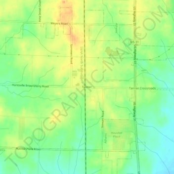
Name: Tanner topographic map, elevation, terrain.
Location: Tanner, Limestone County, Alabama, 35671, United States (34.71148 -86.99056 34.75148 -86.95056)
Average elevation: 199 m
Minimum elevation: 180 m
Maximum elevation: 218 m
Make a donation
Gear up for your next adventure:
As an Amazon Associate, this site earns from qualifying purchases at no extra cost to you.
Other topographic maps
Click on a map to view its topography, its elevation and its terrain.
Lake Ida
United States > Alabama > Limestone County > Athens > Lake Ida Heights
Average elevation: 218 m
Make a donation
Gear up for your next adventure:
As an Amazon Associate, this site earns from qualifying purchases at no extra cost to you.
Lake Ida
United States > Alabama > Limestone County > Athens > Lake Ida Heights
Average elevation: 217 m