Geolocate

Hương Thủy topographic map

Interactive map

Click on the map to display elevation.

About this map

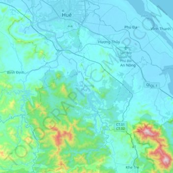
Name: Hương Thủy topographic map, elevation, terrain.

Location: Hương Thủy, Thừa Thiên Huế Province, 53000, Vietnam (16.15678 107.49631 16.48977 107.75735)

Average elevation: 119 m

Minimum elevation: -2 m

Maximum elevation: 1,331 m

Other topographic maps

Click on a map to view its topography, its elevation and its terrain.

Phá Tam Giang

Vietnam > Thừa Thiên Huế Province > Quảng Điền District > Sia

Phá Tam Giang, Sia, Quảng Điền District, Thừa Thiên Huế Province, Vietnam

Average elevation: 2 m

Công viên Bùi Thị Xuân

Vietnam > Thừa Thiên Huế Province > Huế

Công viên Bùi Thị Xuân, Phường Phường Đúc, Huế, Thừa Thiên Huế Province, Vietnam

Average elevation: 9 m

A Lưới District

Vietnam > Thừa Thiên Huế Province

A Lưới District, Thừa Thiên Huế Province, Vietnam

Average elevation: 581 m

Thủy Cam

Vietnam > Thừa Thiên Huế Province > Phú Lộc District

Thủy Cam, Phú Lộc District, Thừa Thiên Huế Province, 51000, Vietnam

Average elevation: 76 m

Mỹ Xuyên

Vietnam > Thừa Thiên Huế Province > Phong Điền District

Mỹ Xuyên, Phong Điền District, Thừa Thiên Huế Province, Vietnam

Average elevation: 5 m

Cồn Hến

Vietnam > Thừa Thiên Huế Province > Hue City

Cồn Hến, Vỹ Dạ, Hue City, Thừa Thiên Huế Province, Vietnam

Average elevation: 5 m

Hue

Vietnam > Thừa Thiên Huế Province > Hue City > Hue

Hue, Hue City, Thừa Thiên Huế Province, 53000, Vietnam

Average elevation: 30 m

Hue City

Vietnam > Thừa Thiên Huế Province

Hue City, Thừa Thiên Huế Province, 54000, Vietnam

Average elevation: 24 m

Bình Định

Vietnam > Thừa Thiên Huế Province > Hương Trà District > Bình Định

Bình Định, Hương Trà District, Thừa Thiên Huế Province, Vietnam

Average elevation: 95 m