
Lake Havasu City topographic map
Interactive map
Click on the map to display elevation.
About this map
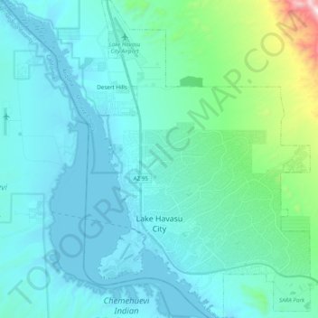
Name: Lake Havasu City topographic map, elevation, terrain.
Location: Lake Havasu City, Mohave County, Arizona, United States (34.43029 -114.37581 34.58960 -114.24202)
Average elevation: 317 m
Minimum elevation: 135 m
Maximum elevation: 1,411 m
Other topographic maps
Click on a map to view its topography, its elevation and its terrain.
Pigeon Point Lighthouse
United States > Arizona > Mohave County > Lake Havasu City
Average elevation: 155 m
Kingman
United States > Arizona > Mohave County
Lt. Edward Fitzgerald Beale, a U.S. Navy officer in the service of the Army Corps of Topographical Engineers, was ordered by the U.S. War Department to build a federal wagon road across the 35th parallel. His secondary orders were to test the feasibility of the use of camels as pack animals in the Southwestern…
Average elevation: 1,131 m
Hoover Dam
United States > Arizona > Mohave County
The amount of electricity generated by Hoover Dam has been decreasing along with the falling water level in Lake Mead due to the prolonged drought in the 2010s and high demand for the Colorado River's water. Lake Mead fell to a new record low elevation of 1,071.61 feet (326.63 m) on July 1, 2016 before…
Average elevation: 429 m
Kingman
United States > Arizona > Mohave County > Kingman
Lt. Edward Fitzgerald Beale, a U.S. Navy officer in the service of the U.S. Army Corps of Topographical Engineers, was ordered by the U.S. War Department to build a federal wagon road across the 35th Parallel. His secondary orders were to test the feasibility of the use of camels as pack animals in the…
Average elevation: 1,135 m
Bullhead City
United States > Arizona > Mohave County
Hardyville Pioneer Cemetery, a small cemetery, now a historic landmark at 35°7′16″N 114°35′17″W / 35.12111°N 114.58806°W / 35.12111; -114.58806, is the most significant existing remnant of Hardyville. An unofficial historical marker for the town is in the parking lot across Highway 95 from…
Average elevation: 322 m