
Le Plat topographic map
Interactive map
Click on the map to display elevation.
About this map
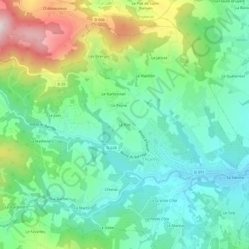
Name: Le Plat topographic map, elevation, terrain.
Average elevation: 472 m
Minimum elevation: 315 m
Maximum elevation: 829 m
Other topographic maps
Click on a map to view its topography, its elevation and its terrain.
La Petite Côte
France > Auvergne-Rhône-Alpes > Rhône > Thurins
La Petite Côte, Thurins, Lyon, Rhône, Auvergne-Rhône-Alpes, France métropolitaine, 69510, France
Average elevation: 431 m
La Valotte
France > Auvergne-Rhône-Alpes > Rhône > Thurins
La Valotte, Thurins, Lyon, Rhône, Auvergne-Rhône-Alpes, France métropolitaine, 69510, France
Average elevation: 392 m
La Goyenche
France > Auvergne-Rhône-Alpes > Rhône > Thurins
La Goyenche, La Valotte, Thurins, Lyon, Rhône, Circonscription départementale du Rhône, Auvergne-Rhône-Alpes, France métropolitaine, 69510, France
Average elevation: 362 m