
Broto topographic map
Interactive map
Click on the map to display elevation.
About this map
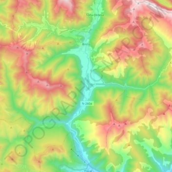
Name: Broto topographic map, elevation, terrain.
Location: Broto, Sobrarbe, Huesca, Aragón, Spanje (42.50181 -0.24619 42.63285 -0.04856)
Average elevation: 1,370 m
Minimum elevation: 747 m
Maximum elevation: 2,230 m
Other topographic maps
Click on a map to view its topography, its elevation and its terrain.
San Juan de Plan/San Chuan de Plan
San Juan de Plan/San Chuan de Plan, Sobrarbe, Huesca, Aragón, 22367, Spanje
Average elevation: 1,974 m
Aínsa
Spanje > Aragón > Sobrarbe > Aínsa-Sobrarbe/L´Aínsa-Sobrarbe
Aínsa, Aínsa-Sobrarbe/L´Aínsa-Sobrarbe, Sobrarbe, Huesca, Aragón, 22330, Spanje
Average elevation: 596 m
Aínsa-Sobrarbe/L´Aínsa-Sobrarbe
Aínsa-Sobrarbe/L´Aínsa-Sobrarbe, Sobrarbe, Huesca, Aragón, Spanje
Average elevation: 762 m
Labuerda/A Buerda
Labuerda/A Buerda, Sobrarbe, Huesca, Aragón, Spanje
Average elevation: 759 m
Griebal
Spanje > Aragón > Sobrarbe > Aínsa-Sobrarbe/L´Aínsa-Sobrarbe
Griebal, Aínsa-Sobrarbe/L´Aínsa-Sobrarbe, Sobrarbe, Huesca, Aragón, 22337, Spanje
Average elevation: 665 m