
Make a donation
Gear up for your next adventure:
As an Amazon Associate, this site earns from qualifying purchases at no extra cost to you.
Pedoulas topographic map
Click on the map to display elevation.
Make a donation
Gear up for your next adventure:
As an Amazon Associate, this site earns from qualifying purchases at no extra cost to you.
Pedoulas
Pedoulas (Greek: Πεδουλάς) is a village in the Nicosia District of Cyprus, located at an altitude of 1,100 metres (3,600 ft) in the Troodos Mountains, 4 km south of Moutoullas. It lies in Marathasa Valley. The name is derived from the words pediada (valley) and laos (people). It is popular summer resort.
Make a donation
Gear up for your next adventure:
As an Amazon Associate, this site earns from qualifying purchases at no extra cost to you.
About this map
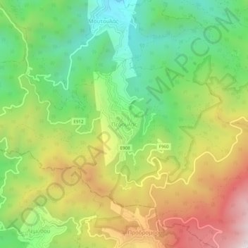
Name: Pedoulas topographic map, elevation, terrain.
Location: Pedoulas, Nicosia District, Cyprus, 2850, Cyprus (34.94739 32.80877 34.98739 32.84877)
Average elevation: 1,142 m
Minimum elevation: 699 m
Maximum elevation: 1,742 m
Make a donation
Gear up for your next adventure:
As an Amazon Associate, this site earns from qualifying purchases at no extra cost to you.