Geolocate

Montech topographic map

Click on the map to display elevation.

About this map
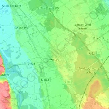
Name: Montech topographic map, elevation, terrain.

Location: Montech, Montauban, Tarn-et-Garonne, Occitania, Metropolitan France, 82700, France (43.91433 1.17535 44.01003 1.29770)

Average elevation: 100 m

Minimum elevation: 76 m

Maximum elevation: 156 m

Other topographic maps

Click on a map to view its topography, its elevation and its terrain.
La Nauze

France > Occitania > Tarn-et-Garonne > Molières > Molières

Average elevation: 140 m

Lac Doux

France > Occitania > Tarn-et-Garonne > Loze > Mas d'Estèbe

Average elevation: 329 m

Badio

France > Occitania > Tarn-et-Garonne > Castelferrus

Average elevation: 101 m

Gear up for your next adventure:

🗺️Ordnance Survey Maps - Official UK maps for walking and outdoor activities
🎒Hiking Daypacks - Compact backpacks ideal for short hikes and excursions
🦟Anti-Midge & Tick Repellent - Vital for hiking in the Scottish Highlands during summer
🧥Softshell Jackets - Breathable jackets for active outdoor use
📦Dry Bags - Waterproof bags to protect gear from rain

As an Amazon Associate, this site earns from qualifying purchases at no extra cost to you.