
Make a donation
Gear up for your next adventure:
As an Amazon Associate, this site earns from qualifying purchases at no extra cost to you.
Uniontown topographic map
Click on the map to display elevation.
Make a donation
Gear up for your next adventure:
As an Amazon Associate, this site earns from qualifying purchases at no extra cost to you.
Uniontown
Uniontown lies within the foothills of the Allegheny Mountains at an elevation of 999 feet (304 meters) above sea level. The city rests at the base of Chestnut Ridge, the westernmost ridge of the Appalachian Mountains.
Make a donation
Gear up for your next adventure:
As an Amazon Associate, this site earns from qualifying purchases at no extra cost to you.
About this map
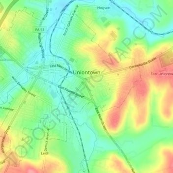
Name: Uniontown topographic map, elevation, terrain.
Location: Uniontown, Fayette County, Pennsylvania, United States (39.88264 -79.74491 39.91217 -79.70325)
Average elevation: 323 m
Minimum elevation: 288 m
Maximum elevation: 374 m
Make a donation
Gear up for your next adventure:
As an Amazon Associate, this site earns from qualifying purchases at no extra cost to you.
Other topographic maps
Click on a map to view its topography, its elevation and its terrain.
Make a donation
Gear up for your next adventure:
As an Amazon Associate, this site earns from qualifying purchases at no extra cost to you.
Chestnut Ridge
United States > Pennsylvania > Fayette County > Redstone Township
Average elevation: 344 m
Make a donation
Gear up for your next adventure:
As an Amazon Associate, this site earns from qualifying purchases at no extra cost to you.
Normalville
United States > Pennsylvania > Fayette County > Springfield Township
Average elevation: 486 m
Arnold City
United States > Pennsylvania > Fayette County > Washington Township
Average elevation: 303 m
Make a donation
Gear up for your next adventure:
As an Amazon Associate, this site earns from qualifying purchases at no extra cost to you.
Normalville
United States > Pennsylvania > Fayette County > Springfield Township
Average elevation: 486 m
Mill Run
United States > Pennsylvania > Fayette County > Springfield Township
Average elevation: 482 m
East Fredricktown
United States > Pennsylvania > Fayette County > Luzerne Township
Average elevation: 302 m
Make a donation
Gear up for your next adventure:
As an Amazon Associate, this site earns from qualifying purchases at no extra cost to you.