
Storey County topographic map
Click on the map to display elevation.
About this map
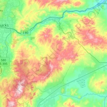
Name: Storey County topographic map, elevation, terrain.
Location: Storey County, Nevada, 89440, United States of America (39.25084 -119.71446 39.63176 -119.27420)
Average elevation: 1,595 m
Minimum elevation: 1,238 m
Maximum elevation: 2,367 m
Other topographic maps
Click on a map to view its topography, its elevation and its terrain.
Incline Village
United States of America > Nevada > Incline Village > Incline Village
Average elevation: 2,175 m