
Make a donation
Gear up for your next adventure:
As an Amazon Associate, this site earns from qualifying purchases at no extra cost to you.
Jackson topographic map
Click on the map to display elevation.
Make a donation
Gear up for your next adventure:
As an Amazon Associate, this site earns from qualifying purchases at no extra cost to you.
Jackson
The area was inhabited by the Northern Sierra Indians, who occupied areas along creeks, spring, and seep areas, including permanent and seasonal drainages, flat ridges, and terraces. Therefore, areas along watercourses are considered likely locations for prehistoric cultural resources. Permanent villages were usually placed on elevations above seasonal flood levels. Surrounding areas were used for hunting and seed, acorn, and grass gathering.
Make a donation
Gear up for your next adventure:
As an Amazon Associate, this site earns from qualifying purchases at no extra cost to you.
About this map
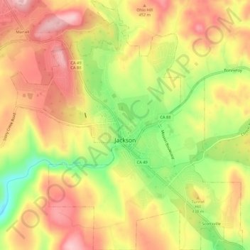
Name: Jackson topographic map, elevation, terrain.
Location: Jackson, Amador County, California, United States (38.33029 -120.79857 38.37216 -120.74896)
Average elevation: 421 m
Minimum elevation: 300 m
Maximum elevation: 512 m
Make a donation
Gear up for your next adventure:
As an Amazon Associate, this site earns from qualifying purchases at no extra cost to you.
Other topographic maps
Click on a map to view its topography, its elevation and its terrain.
Make a donation
Gear up for your next adventure:
As an Amazon Associate, this site earns from qualifying purchases at no extra cost to you.
Sutter Creek
United States > California > Amador County > Sutter Creek > Sutter Creek
Average elevation: 435 m
Make a donation
Gear up for your next adventure:
As an Amazon Associate, this site earns from qualifying purchases at no extra cost to you.