

Fiddletown topographic map
Click on the map to display elevation.
About this map
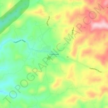
Name: Fiddletown topographic map, elevation, terrain.
Average elevation: 571 m
Minimum elevation: 459 m
Maximum elevation: 707 m
Other topographic maps
Click on a map to view its topography, its elevation and its terrain.
Jackson
United States > California > Amador County
The area was inhabited by the Northern Sierra Indians, who occupied areas along creeks, spring, and seep areas, including permanent and seasonal drainages, flat ridges, and terraces. Therefore, areas along watercourses are considered likely locations for prehistoric cultural resources. Permanent villages were…
Average elevation: 421 m

Volcano
United States > California > Amador County > Volcano
Volcano (formerly Soldier's Gulch and The Volcano) is a census-designated place in Amador County, California. It lies at an elevation of 2,070 feet (631 m). The population was 104 at the 2020 census. It is located at 38°26′35″N 120°37′51″W / 38.44306°N 120.63083°W / 38.44306; -120.63083,…
Average elevation: 748 m
Volcano
United States > California > Amador County > Volcano
Volcano (formerly Soldier's Gulch and The Volcano) is a census-designated place in Amador County, California. It lies at an elevation of 2,070 feet (631 m). The population was 104 at the 2020 census. It is located at 38°26′35″N 120°37′51″W / 38.44306°N 120.63083°W / 38.44306; -120.63083,…
Average elevation: 748 m
Jackson
United States > California > Amador County
The area was inhabited by the Northern Sierra Indians, who occupied areas along creeks, spring, and seep areas, including permanent and seasonal drainages, flat ridges, and terraces. Therefore, areas along watercourses are considered likely locations for prehistoric cultural resources. Permanent villages were…
Average elevation: 421 m
Jackson
United States > California > Amador County
The area was inhabited by the Northern Sierra Indians, who occupied areas along creeks, spring, and seep areas, including permanent and seasonal drainages, flat ridges, and terraces. Therefore, areas along watercourses are considered likely locations for prehistoric cultural resources. Permanent villages were…
Average elevation: 421 m