
Make a donation
Gear up for your next adventure:
As an Amazon Associate, this site earns from qualifying purchases at no extra cost to you.
Stryck topographic map
Click on the map to display elevation.
Make a donation
Gear up for your next adventure:
As an Amazon Associate, this site earns from qualifying purchases at no extra cost to you.
Stryck
Stryck befindet sich knapp zwei Kilometer (Luftlinie) südsüdöstlich vom Willinger Ortskern im Tal der Itter (südwestlicher Zufluss der Diemel) auf Höhen zwischen 590 und 630 m ü. NHN. Die Berge der Dorfumgebung sind alle über 700 m hoch; der höchste Berg ist der westlich gelegene Ettelsberg (837,7 m), südwestlich erhebt sich der Mühlenkopf (ca. 815 m) mit der Mühlenkopfschanze. Nördlich von Stryck liegt im Übergangsbereich zu Willingen der östlich von der Itter passierte Stryckteich.
Make a donation
Gear up for your next adventure:
As an Amazon Associate, this site earns from qualifying purchases at no extra cost to you.
About this map
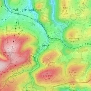
Name: Stryck topographic map, elevation, terrain.
Average elevation: 674 m
Minimum elevation: 535 m
Maximum elevation: 840 m
Make a donation
Gear up for your next adventure:
As an Amazon Associate, this site earns from qualifying purchases at no extra cost to you.