
Make a donation
Gear up for your next adventure:
As an Amazon Associate, this site earns from qualifying purchases at no extra cost to you.
Tannourine topographic map
Click on the map to display elevation.
Make a donation
Gear up for your next adventure:
As an Amazon Associate, this site earns from qualifying purchases at no extra cost to you.
Tannourine
Tannourine is the plural of the Syriac word tannour, which indicates an old stone oven. Tannourine's name may in fact stem from the local topography, which resembles the convex form of an oven called tannour, with the dual suffix ine as a reference to the two distinct areas of Tannourine Al-Tahta (literally Lower Tannourine) and Tannourine Al-Fawqa (literally Upper Tannourine).
Make a donation
Gear up for your next adventure:
As an Amazon Associate, this site earns from qualifying purchases at no extra cost to you.
About this map
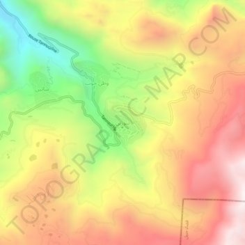
Name: Tannourine topographic map, elevation, terrain.
Location: Tannourine, Batroun District, North Governorate, Lebanon (34.16434 35.88272 34.20434 35.92272)
Average elevation: 1,601 m
Minimum elevation: 973 m
Maximum elevation: 2,128 m
Make a donation
Gear up for your next adventure:
As an Amazon Associate, this site earns from qualifying purchases at no extra cost to you.
Other topographic maps
Click on a map to view its topography, its elevation and its terrain.
Zgharta District
The district at elevations from 40–2,550 metres (130–8,370 ft), from near the coast to its highest point in the Mount Lebanon mountain range.
Average elevation: 527 m
Make a donation
Gear up for your next adventure:
As an Amazon Associate, this site earns from qualifying purchases at no extra cost to you.
Tripoli
The urban form of Mamluk Tripoli was dictated mainly by climate, site configuration, defense, and urban aesthetics. The layout of major thoroughfares was set according to prevailing winds and topography. The city had no fortifications, but heavy building construction characterized by compact urban forms,…
Average elevation: 42 m
Make a donation
Gear up for your next adventure:
As an Amazon Associate, this site earns from qualifying purchases at no extra cost to you.
Make a donation
Gear up for your next adventure:
As an Amazon Associate, this site earns from qualifying purchases at no extra cost to you.
Make a donation
Gear up for your next adventure:
As an Amazon Associate, this site earns from qualifying purchases at no extra cost to you.
Make a donation
Gear up for your next adventure:
As an Amazon Associate, this site earns from qualifying purchases at no extra cost to you.
Tripoli
The urban form of Mamluk Tripoli was dictated mainly by climate, site configuration, defense, and urban aesthetics. The layout of major thoroughfares was set according to prevailing winds and topography. The city had no fortifications, but heavy building construction characterized by compact urban forms,…
Average elevation: 42 m
Make a donation
Gear up for your next adventure:
As an Amazon Associate, this site earns from qualifying purchases at no extra cost to you.
Miniyeh
Miniyeh (Arabic: المنية, French: Minieh) is the capital of the Miniyeh-Danniyeh District in North Governorate of Lebanon. Minya is located 96 km from Beirut at an altitude of 20 m above sea level.
Average elevation: 30 m