
Pragela topographic map
Interactive map
Click on the map to display elevation.
About this map
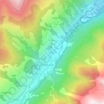
Name: Pragela topographic map, elevation, terrain.
Location: Pragela, Pragelato, Turin, Piémont, Italie (44.99622 6.92245 45.03622 6.96245)
Average elevation: 1,871 m
Minimum elevation: 1,436 m
Maximum elevation: 2,564 m
Other topographic maps
Click on a map to view its topography, its elevation and its terrain.
Granges di Pragelato
Italie > Piémont > Pragelato > Pragela > Granges di Pragelato
Granges di Pragelato, Pragela, Pragelato, Turin, Piémont, Italie
Average elevation: 1,879 m