
South Oxfordshire topographic map
Interactive map
Click on the map to display elevation.
About this map
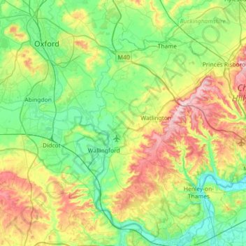
Name: South Oxfordshire topographic map, elevation, terrain.
Location: South Oxfordshire, Oxfordshire, England, United Kingdom (51.45941 -1.29024 51.81377 -0.87007)
Average elevation: 97 m
Minimum elevation: 28 m
Maximum elevation: 260 m
Other topographic maps
Click on a map to view its topography, its elevation and its terrain.
Oxford
United Kingdom > England > Oxfordshire
Oxford, Oxfordshire, England, United Kingdom
Average elevation: 81 m
Abingdon
United Kingdom > England > Oxfordshire > Vale of White Horse
Abingdon, Vale of White Horse, Oxfordshire, England, OX14 3UJ, United Kingdom
Average elevation: 64 m
Cote
United Kingdom > England > Oxfordshire > West Oxfordshire > Aston
Cote, Aston, Cote, Shifford and Chimney, Aston, West Oxfordshire, Oxfordshire, England, OX18 2EG, United Kingdom
Average elevation: 67 m
Steeple Barton
United Kingdom > England > Oxfordshire > West Oxfordshire
Steeple Barton, West Oxfordshire, Oxfordshire, England, United Kingdom
Average elevation: 129 m
Glympton
United Kingdom > England > Oxfordshire > West Oxfordshire
Glympton, West Oxfordshire, Oxfordshire, England, United Kingdom
Average elevation: 123 m
Great Bourton
United Kingdom > England > Oxfordshire > Cherwell District
Great Bourton, Cherwell District, Oxfordshire, England, OX17 1QP, United Kingdom
Average elevation: 118 m
Charlton-on-Otmoor
United Kingdom > England > Oxfordshire > Cherwell District
Charlton-on-Otmoor, Cherwell District, Oxfordshire, England, United Kingdom
Average elevation: 62 m
Newnham Murren
United Kingdom > England > Oxfordshire > South Oxfordshire > Crowmarsh Gifford
Newnham Murren, Crowmarsh, Crowmarsh Gifford, South Oxfordshire, Oxfordshire, England, OX10 8BW, United Kingdom
Average elevation: 59 m
Maidensgrove
United Kingdom > England > Oxfordshire > South Oxfordshire
Maidensgrove, Pishill with Stonor, South Oxfordshire, Oxfordshire, England, RG9 6HA, United Kingdom
Average elevation: 152 m
Kingwood Common
United Kingdom > England > Oxfordshire > South Oxfordshire > Highmoor
Kingwood Common, Highmoor, South Oxfordshire, Oxfordshire, England, United Kingdom
Average elevation: 125 m
Finstock
United Kingdom > England > Oxfordshire > West Oxfordshire
Finstock, West Oxfordshire, Oxfordshire, England, United Kingdom
Average elevation: 127 m
Little Coxwell
United Kingdom > England > Oxfordshire > Vale of White Horse
Little Coxwell, Vale of White Horse, Oxfordshire, England, United Kingdom
Average elevation: 111 m
Steventon
United Kingdom > England > Oxfordshire > Vale of White Horse
Steventon, Vale of White Horse, Oxfordshire, England, United Kingdom
Average elevation: 69 m
Twyford
United Kingdom > England > Oxfordshire > Cherwell District
Twyford, Cherwell District, Oxfordshire, England, OX17 3HS, United Kingdom
Average elevation: 103 m
Buscot
United Kingdom > England > Oxfordshire > Vale of White Horse
Buscot, Vale of White Horse, Oxfordshire, England, United Kingdom
Average elevation: 81 m
Woodeaton
United Kingdom > England > Oxfordshire > South Oxfordshire
Woodeaton, South Oxfordshire, Oxfordshire, England, OX3 9TJ, United Kingdom
Average elevation: 72 m
Henley-on-Thames
United Kingdom > England > Oxfordshire > South Oxfordshire
Henley-on-Thames, South Oxfordshire, Oxfordshire, England, RG9 2AN, United Kingdom
Average elevation: 78 m
Shipton-on-Cherwell
United Kingdom > England > Oxfordshire > Cherwell District
Shipton-on-Cherwell, Cherwell District, Oxfordshire, England, OX5 1JN, United Kingdom
Average elevation: 78 m
Swalcliffe
United Kingdom > England > Oxfordshire > Cherwell District
Swalcliffe, Cherwell District, Oxfordshire, England, United Kingdom
Average elevation: 163 m
Fringford
United Kingdom > England > Oxfordshire > Cherwell District
Fringford, Cherwell District, Oxfordshire, England, United Kingdom
Average elevation: 99 m
Garford
United Kingdom > England > Oxfordshire > Vale of White Horse
Garford, Vale of White Horse, Oxfordshire, England, United Kingdom
Average elevation: 61 m
Little Haseley
United Kingdom > England > Oxfordshire > South Oxfordshire > Great Haseley
Little Haseley, Great Haseley, South Oxfordshire, Oxfordshire, England, OX44 7LN, United Kingdom
Average elevation: 73 m
Watlington Hill
United Kingdom > England > Oxfordshire > South Oxfordshire > Watlington
Watlington Hill, Watlington, South Oxfordshire, Oxfordshire, England, United Kingdom
Average elevation: 189 m
Noke
United Kingdom > England > Oxfordshire > Cherwell District
Noke, Cherwell District, Oxfordshire, England, United Kingdom
Average elevation: 68 m
Baldon Row
United Kingdom > England > Oxfordshire > South Oxfordshire > Toot Baldon
Baldon Row, Toot Baldon, South Oxfordshire, Oxfordshire, England, OX44 9NE, United Kingdom
Average elevation: 73 m
Harpsden Wood
United Kingdom > England > Oxfordshire > South Oxfordshire > Henley-on-Thames > Harpsden
Harpsden Wood, Harpsden, Henley-on-Thames, South Oxfordshire, Oxfordshire, England, RG9 4AU, United Kingdom
Average elevation: 63 m
River Evenlode
United Kingdom > England > Oxfordshire
River Evenlode, Oxfordshire, England, United Kingdom
Average elevation: 138 m
Moulsford
United Kingdom > England > Oxfordshire > South Oxfordshire
Moulsford, South Oxfordshire, Oxfordshire, England, United Kingdom
Average elevation: 67 m
Wootton
United Kingdom > England > Oxfordshire > West Oxfordshire
Wootton, West Oxfordshire, Oxfordshire, England, United Kingdom
Average elevation: 112 m
Hornton
United Kingdom > England > Oxfordshire > Cherwell District
Hornton, Cherwell District, Oxfordshire, England, United Kingdom
Average elevation: 172 m
Souldern
United Kingdom > England > Oxfordshire > Cherwell District
Souldern, Cherwell District, Oxfordshire, England, United Kingdom
Average elevation: 115 m
Middle Assendon
United Kingdom > England > Oxfordshire > South Oxfordshire
Middle Assendon, Bix and Assendon, South Oxfordshire, Oxfordshire, England, RG9 6AT, United Kingdom
Average elevation: 109 m
Water Eaton
United Kingdom > England > Oxfordshire > Cherwell District
Water Eaton, Gosford and Water Eaton, Cherwell District, Oxfordshire, England, OX2 8HD, United Kingdom
Average elevation: 63 m
Wardington
United Kingdom > England > Oxfordshire > Cherwell District
Wardington, Cherwell District, Oxfordshire, England, United Kingdom
Average elevation: 125 m
Stadhampton
United Kingdom > England > Oxfordshire > South Oxfordshire
Stadhampton, South Oxfordshire, Oxfordshire, England, United Kingdom
Average elevation: 61 m
Botley Stream
United Kingdom > England > Oxfordshire > Oxford
Botley Stream, New Botley, West Oxford, Oxford, Oxfordshire, England, OX2 0ED, United Kingdom
Average elevation: 67 m
Clifton Hampden
United Kingdom > England > Oxfordshire > South Oxfordshire > Clifton Hampden
Clifton Hampden, South Oxfordshire, Oxfordshire, England, United Kingdom
Average elevation: 58 m
Little Lews
United Kingdom > England > Oxfordshire > Vale of White Horse > Ardington
Little Lews, Ardington, Vale of White Horse, Oxfordshire, England, United Kingdom
Average elevation: 183 m
Merton
United Kingdom > England > Oxfordshire > Cherwell District
Merton, Cherwell District, Oxfordshire, England, United Kingdom
Average elevation: 63 m
Aston Tirrold
United Kingdom > England > Oxfordshire > South Oxfordshire
Aston Tirrold, South Oxfordshire, Oxfordshire, England, United Kingdom
Average elevation: 84 m
Gatehampton
United Kingdom > England > Oxfordshire > South Oxfordshire > Goring-on-Thames
Gatehampton, Goring-on-Thames, South Oxfordshire, Oxfordshire, England, RG8 9LU, United Kingdom
Average elevation: 88 m
Sutton Wick
United Kingdom > England > Oxfordshire > Vale of White Horse > Abingdon > Drayton
Sutton Wick, Drayton, Abingdon, Vale of White Horse, Oxfordshire, England, OX14 4HH, United Kingdom
Average elevation: 57 m
Wet n Wild Oxford
United Kingdom > England > Oxfordshire > South Oxfordshire > Berinsfield
Wet n Wild Oxford, Drayton Road, Berinsfield, Dorchester On Thames, South Oxfordshire, Oxfordshire, England, OX10 7PQ, United Kingdom
Average elevation: 51 m
Ipsden
United Kingdom > England > Oxfordshire > South Oxfordshire
Ipsden, South Oxfordshire, Oxfordshire, England, United Kingdom
Average elevation: 128 m
Idbury
United Kingdom > England > Oxfordshire > West Oxfordshire
Idbury, West Oxfordshire, Oxfordshire, England, United Kingdom
Average elevation: 147 m
Great Park
United Kingdom > England > Oxfordshire > West Oxfordshire > Long Hanborough
Great Park, Blenheim, Long Hanborough, West Oxfordshire, Oxfordshire, England, United Kingdom
Average elevation: 94 m
Wytham
United Kingdom > England > Oxfordshire > Vale of White Horse
Wytham, Vale of White Horse, Oxfordshire, England, United Kingdom
Average elevation: 82 m
Fencott
United Kingdom > England > Oxfordshire > Cherwell District
Fencott, Cherwell District, Oxfordshire, England, OX5 2RD, United Kingdom
Average elevation: 61 m
Epwell
United Kingdom > England > Oxfordshire > Cherwell District
Epwell, Cherwell District, Oxfordshire, England, United Kingdom
Average elevation: 181 m
Little Wittenham
United Kingdom > England > Oxfordshire > South Oxfordshire
Little Wittenham, South Oxfordshire, Oxfordshire, England, United Kingdom
Average elevation: 61 m