
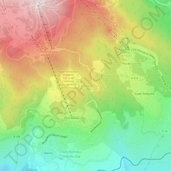
L'Ermitage topographic map
Interactive map
Click on the map to display elevation.
About this map
Name: L'Ermitage topographic map, elevation, terrain.
Average elevation: 1,785 m
Minimum elevation: 1,491 m
Maximum elevation: 2,130 m
Other topographic maps
Click on a map to view its topography, its elevation and its terrain.
Font-Romeu
France > Occitanie > Pyrénées-Orientales > Font-Romeu-Odeillo-Via
Font-Romeu, Font-Romeu-Odeillo-Via, Prades, Pyrénées-Orientales, Occitanie, France métropolitaine, 66120, France
Average elevation: 1,710 m
Via
France > Occitanie > Pyrénées-Orientales > Font-Romeu-Odeillo-Via
Via, Font-Romeu-Odeillo-Via, Prades, Pyrénées-Orientales, Occitanie, France métropolitaine, 66120, France
Average elevation: 1,551 m
Odeillo
France > Occitanie > Pyrénées-Orientales > Font-Romeu-Odeillo-Via
Odeillo, Font-Romeu-Odeillo-Via, Prades, Pyrénées-Orientales, Occitanie, France métropolitaine, 66120, France
Average elevation: 1,631 m