
Make a donation
Gear up for your next adventure:
As an Amazon Associate, this site earns from qualifying purchases at no extra cost to you.
Les Davids topographic map
Click on the map to display elevation.
Make a donation
Gear up for your next adventure:
As an Amazon Associate, this site earns from qualifying purchases at no extra cost to you.
About this map
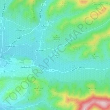
Name: Les Davids topographic map, elevation, terrain.
Average elevation: 121 m
Minimum elevation: 55 m
Maximum elevation: 327 m
Make a donation
Gear up for your next adventure:
As an Amazon Associate, this site earns from qualifying purchases at no extra cost to you.
Other topographic maps
Click on a map to view its topography, its elevation and its terrain.
Le Réal Martin
France > Provence-Alpes-Côte d'Azur > Var > Pierrefeu-du-Var
La longueur de son cours d'eau est de 28 km. Le Réal Martin prend sa source, à l'altitude 215 mètres, sur la commune de Pignans, près du lieu-dit les Plaines, au nord de la Forêt domaniale des Maures et des sommets Le Cros de Panau (684 m) et Notre-Dame des Anges (768 m).
Average elevation: 176 m