
Make a donation
Gear up for your next adventure:
As an Amazon Associate, this site earns from qualifying purchases at no extra cost to you.
Valparaiso Region topographic map
Click on the map to display elevation.
Make a donation
Gear up for your next adventure:
As an Amazon Associate, this site earns from qualifying purchases at no extra cost to you.
About this map
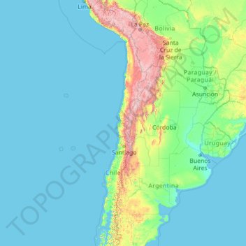
Name: Valparaiso Region topographic map, elevation, terrain.
Location: Valparaiso Region, Chile (-33.95619 -109.45487 -26.27333 -69.98916)
Average elevation: 376 m
Minimum elevation: 0 m
Maximum elevation: 6,527 m
Make a donation
Gear up for your next adventure:
As an Amazon Associate, this site earns from qualifying purchases at no extra cost to you.
Other topographic maps
Click on a map to view its topography, its elevation and its terrain.
Atacama Desert
Chile > Antofagasta Region > Provincia de Antofagasta > Antofagasta
The Coastal Cliff of northern Chile west of the Chilean Coast Range is the main topographical feature of the coast. The geomorphology of the Atacama Desert has been characterized as a low-relief bench "similar to a giant uplifted terrace" by Armijo and co-workers. The intermediate depression (or Central…
Average elevation: 1,961 m
Santiago
Chile > Santiago Metropolitan Region > Provincia de Santiago
The city lies in the center of the Santiago Basin, a large bowl-shaped valley consisting of broad and fertile lands surrounded by mountains. The city has a varying elevation, gradually increasing from 400 m (1,312 ft) in the western areas to more than 700 m (2,297 ft) in the eastern areas. Santiago's…
Average elevation: 722 m
Ma'uŋa Te Hoŋa (O Koro)
Chile > Valparaiso Region > Easter Island Province > Easter Island
Average elevation: 255 m
Make a donation
Gear up for your next adventure:
As an Amazon Associate, this site earns from qualifying purchases at no extra cost to you.
Santiago
Chile > Santiago Metropolitan Region > Provincia de Santiago
The city lies in the center of the Santiago Basin, a large bowl-shaped valley consisting of broad and fertile lands surrounded by mountains. The city has a varying elevation, gradually increasing from 400 meters (1,300 feet) in the western areas to more than 700 m (2,297 ft) in the eastern areas. Santiago's…
Average elevation: 722 m
Santa Rita Sur
Chile > Santiago Metropolitan Region > Provincia de Cordillera
Average elevation: 760 m
Socaire
Chile > Antofagasta Region > Provincia de El Loa > San Pedro de Atacama
Average elevation: 3,291 m
Make a donation
Gear up for your next adventure:
As an Amazon Associate, this site earns from qualifying purchases at no extra cost to you.
Mirador Cóndor
Chile > Magallanes and Chilean Antarctica Region > Provincia de Última Esperanza > Torres del Paine
Average elevation: 140 m
Cerro El Monstruo
Chile > Los Lagos Region > Provincia de Llanquihue > Cochamó
Average elevation: 1,296 m
Make a donation
Gear up for your next adventure:
As an Amazon Associate, this site earns from qualifying purchases at no extra cost to you.
Yendegaia
Chile > Magallanes and Chilean Antarctica Region > Provincia de la Antártica Chilena > Cape Horn
Average elevation: 91 m
Camar
Chile > Antofagasta Region > Provincia de El Loa > San Pedro de Atacama
Average elevation: 2,722 m
Puerto Guadal
Chile > Aysen del General Carlos Ibanez del Campo Region > Provincia de General Carrera > Chile Chico
Average elevation: 347 m
Make a donation
Gear up for your next adventure:
As an Amazon Associate, this site earns from qualifying purchases at no extra cost to you.
Isla Carmen
Chile > Aysen del General Carlos Ibanez del Campo Region > Provincia de Aysén > Puerto Aysén
Average elevation: 22 m
Ojos del Salado
Chile > Atacama Region > Provincia de Copiapó > Copiapó
Nevado Ojos del Salado is a dormant complex volcano in the Andes on the Argentina–Chile border. It is the highest volcano on Earth and the highest peak in Chile. The upper reaches of Ojos del Salado consist of several overlapping lava domes, lava flows and volcanic craters, with sparse ice cover. The complex…
Average elevation: 6,446 m
Carretera Austral
Chile > Aysen del General Carlos Ibanez del Campo Region > Provincia de General Carrera > Río Ibáñez
Average elevation: 414 m
Santiago
Chile > Santiago Metropolitan Region > Provincia de Santiago
The city lies in the center of the Santiago Basin, a large bowl-shaped valley consisting of broad and fertile lands surrounded by mountains. The city has a varying elevation, gradually increasing from 400 m (1,312 ft) in the western areas to more than 700 m (2,297 ft) in the eastern areas. Santiago's…
Average elevation: 722 m
Make a donation
Gear up for your next adventure:
As an Amazon Associate, this site earns from qualifying purchases at no extra cost to you.
Agua de la Gloria
Chile > Biobío Region > Provincia de Concepción > Concepcion > El Pino
Average elevation: 94 m
Valle Ascensio
Chile > Magallanes and Chilean Antarctica Region > Provincia de Última Esperanza > Torres del Paine
Average elevation: 1,060 m
Cerro Ballena
Chile > Magallanes and Chilean Antarctica Region > Provincia de Última Esperanza
Average elevation: 400 m
Make a donation
Gear up for your next adventure:
As an Amazon Associate, this site earns from qualifying purchases at no extra cost to you.
Peteroa
Chile > Maule Region > Provincia de Curicó > Sagrada Familia > Santa Ana
Average elevation: 139 m
Cape Horn
Chile > Magallanes and Chilean Antarctica Region > Provincia de la Antártica Chilena > Cape Horn
Average elevation: 40 m
Cerro Penitentes
Chile > Santiago Metropolitan Region > Provincia de Cordillera > San José de Maipo
Average elevation: 3,717 m
Make a donation
Gear up for your next adventure:
As an Amazon Associate, this site earns from qualifying purchases at no extra cost to you.
Puerto Natales
Chile > Magallanes and Chilean Antarctica Region > Provincia de Última Esperanza
Average elevation: 141 m
Caleta Camarones
Chile > Arica y Parinacota Region > Provincia de Arica > Camarones
Average elevation: 188 m
Make a donation
Gear up for your next adventure:
As an Amazon Associate, this site earns from qualifying purchases at no extra cost to you.
Tronador
Chile > Los Lagos Region > Provincia de Llanquihue > Puerto Varas
Tronador (Spanish: Cerro Tronador) is an extinct stratovolcano in the southern Andes, located along the border between Argentina and Chile, near the Argentine city of Bariloche. The mountain was named Tronador (Spanish for "Thunderer") by locals in reference to the sound of falling seracs. With an altitude of…
Average elevation: 2,836 m
Los Rosales
Chile > Valparaiso Region > Provincia de Los Andes > Calle Larga
Average elevation: 1,235 m
Make a donation
Gear up for your next adventure:
As an Amazon Associate, this site earns from qualifying purchases at no extra cost to you.
Norte Grande
Chile > Antofagasta Region > Provincia de Antofagasta > Sierra Gorda
The desert region is an elevated arid plateau descending gradually from the Andes towards the coast, where it breaks down abruptly from elevations of 800 to 1500 ft. From the sea this plateau escarpment has the appearance of a range of flat topped hills closely following the coast line. This topography…
Average elevation: 2,112 m
La Chupalla
Chile > Valparaiso Region > Provincia de San Felipe de Aconcagua > Llay-Llay
Average elevation: 850 m
Valle de Luna
Chile > Santiago Metropolitan Region > Provincia de Chacabuco > Lampa
Average elevation: 609 m
Make a donation
Gear up for your next adventure:
As an Amazon Associate, this site earns from qualifying purchases at no extra cost to you.
Puerto Natales
Chile > Magallanes and Chilean Antarctica Region > Provincia de Última Esperanza
Average elevation: 141 m
El Peumo
Chile > Santiago Metropolitan Region > Provincia de Talagante > Talagante
Average elevation: 324 m
Atacama Desert
Chile > Antofagasta Region > Provincia de Antofagasta > Antofagasta
The Coastal Cliff of northern Chile west of the Chilean Coast Range is the main topographical feature of the coast. The geomorphology of the Atacama Desert has been characterized as a low-relief bench "similar to a giant uplifted terrace" by Armijo and co-workers. The intermediate depression (or Central…
Average elevation: 1,961 m
Make a donation
Gear up for your next adventure:
As an Amazon Associate, this site earns from qualifying purchases at no extra cost to you.
Humedal Desembocadura del Río Copiapó
Chile > Atacama Region > Provincia de Copiapó > Caldera
Average elevation: 31 m
Make a donation
Gear up for your next adventure:
As an Amazon Associate, this site earns from qualifying purchases at no extra cost to you.
Volcán Llullaillaco
Chile > Antofagasta Region > Provincia de Antofagasta > Antofagasta
Llullaillaco (Spanish: [ʎuʎajˈʎako], Latin American Spanish: [ɟʝuʝajˈʝako]) is a dormant stratovolcano on the border between Argentina (Salta Province) and Chile (Antofagasta Region). It is part of the Llullaillaco National Park and lies in the Puna de Atacama, a region of tall volcanic peaks on a…
Average elevation: 6,187 m
Isla Florencia
Chile > Aysen del General Carlos Ibanez del Campo Region > Provincia de Aysén > Cisnes
Average elevation: 13 m
Río del Valle
Chile > O'Higgins Region > Provincia de Colchagua > San Fernando
Average elevation: 1,997 m
Make a donation
Gear up for your next adventure:
As an Amazon Associate, this site earns from qualifying purchases at no extra cost to you.
Cape Horn
Chile > Magallanes and Chilean Antarctica Region > Provincia de la Antártica Chilena > Cape Horn
Average elevation: 49 m
Puerto Natales
Chile > Magallanes and Chilean Antarctica Region > Provincia de Última Esperanza
Average elevation: 141 m
Playa Laguna Verde
Chile > Valparaiso Region > Provincia de Valparaíso > Valparaíso > Laguna Verde
Average elevation: 70 m
Make a donation
Gear up for your next adventure:
As an Amazon Associate, this site earns from qualifying purchases at no extra cost to you.
Terevaka
Chile > Valparaiso Region > Easter Island Province > Easter Island
Terevaka is the 12th most topographically isolated summit on Earth.
Average elevation: 384 m
Santa Mónica Norte
Chile > Santiago Metropolitan Region > Provincia de Talagante
Average elevation: 487 m
Make a donation
Gear up for your next adventure:
As an Amazon Associate, this site earns from qualifying purchases at no extra cost to you.
Cerro Arco
Chile > Aysen del General Carlos Ibanez del Campo Region > Provincia de Capitán Prat > Cochrane
Average elevation: 2,456 m
Sierras de Bellavista Alto
Chile > O'Higgins Region > Provincia de Colchagua > San Fernando
Average elevation: 1,126 m
Make a donation
Gear up for your next adventure:
As an Amazon Associate, this site earns from qualifying purchases at no extra cost to you.
San Alfonso
Chile > Santiago Metropolitan Region > Provincia de Cordillera > San José de Maipo
Average elevation: 1,372 m
Punta Pite
Chile > Valparaiso Region > Provincia de Petorca > Zapallar > Punta Pite Norte
Average elevation: 35 m
El Molino Viejo
Chile > O'Higgins Region > Provincia de Cachapoal > Requínoa > Pichiguao
Average elevation: 373 m
Make a donation
Gear up for your next adventure:
As an Amazon Associate, this site earns from qualifying purchases at no extra cost to you.
Puerto Natales
Chile > Magallanes and Chilean Antarctica Region > Provincia de Última Esperanza
Average elevation: 141 m
Valle Nevado
Chile > Santiago Metropolitan Region > Provincia de Santiago > Lo Barnechea
Due to its elevation, Valle Nevado has a subalpine climate (Dfc, according to the Köppen climate classification, bordering on Dfb and ET), with drier summers and humid winters, with an average annual precipitation of 1,042 mm (41 in). Summers are chilly and dry, while winters are cold and snowy.
Average elevation: 2,811 m
Make a donation
Gear up for your next adventure:
As an Amazon Associate, this site earns from qualifying purchases at no extra cost to you.
Puyuhuapi
Chile > Aysen del General Carlos Ibanez del Campo Region > Provincia de Aysén > Cisnes
Average elevation: 229 m
Puerto Natales
Chile > Magallanes and Chilean Antarctica Region > Provincia de Última Esperanza
Average elevation: 141 m
Valle del Aconcagua
Chile > Valparaiso Region > Provincia de Quillota > Hijuelas > La Sombra
Average elevation: 349 m
Make a donation
Gear up for your next adventure:
As an Amazon Associate, this site earns from qualifying purchases at no extra cost to you.
Make a donation
Gear up for your next adventure:
As an Amazon Associate, this site earns from qualifying purchases at no extra cost to you.
Punta Roa
Chile > Valparaiso Region > Easter Island Province > Easter Island > Hanga Roa
Average elevation: 11 m
Cerro San Cristóbal
Chile > Santiago Metropolitan Region > Provincia de Santiago
The summit of Cerro San Cristóbal can be reached by foot (about a 45-minute walk, involving a 300m change in elevation), by car via the road joining the Santiago Metropolitan Park, by the Funicular de Santiago (the base of which sits next to the Zoo at the North end of Pio Nono in Barrio Bellavista), or by a…
Average elevation: 615 m
Make a donation
Gear up for your next adventure:
As an Amazon Associate, this site earns from qualifying purchases at no extra cost to you.
Canal de Relave Codelco División El Teniente
Chile > Provincia de Cachapoal > Requínoa
Average elevation: 629 m
Plaza de Armas
Chile > Coquimbo Region > Provincia de Limarí > Ovalle > Sotaquí
Average elevation: 290 m
Make a donation
Gear up for your next adventure:
As an Amazon Associate, this site earns from qualifying purchases at no extra cost to you.
Zona Central
Chile > Maule Region > Provincia de Curicó > Teno
The topography of central Chile includes a coastal range of mountains running parallel to the Andes. Lying between the two mountain ranges is the so-called Central Valley, which contains some of the richest agricultural land in the country, especially in its northern portion. The area just north and south of…
Average elevation: 1,121 m
Parque Industrial Los Libertadores
Chile > Santiago Metropolitan Region > Provincia de Chacabuco > Colina
Average elevation: 520 m
Make a donation
Gear up for your next adventure:
As an Amazon Associate, this site earns from qualifying purchases at no extra cost to you.
Make a donation
Gear up for your next adventure:
As an Amazon Associate, this site earns from qualifying purchases at no extra cost to you.
Tupungato
Chile > Santiago Metropolitan Region > Provincia de Cordillera > San José de Maipo
Average elevation: 6,002 m
Make a donation
Gear up for your next adventure:
As an Amazon Associate, this site earns from qualifying purchases at no extra cost to you.