
Thank you for supporting this site ❤️
Make a donation
Make a donation
Gear up for your next adventure:
As an Amazon Associate, this site earns from qualifying purchases at no extra cost to you.
Tenerife topographic map
Click on the map to display elevation.
Thank you for supporting this site ❤️
Make a donation
Make a donation
Gear up for your next adventure:
As an Amazon Associate, this site earns from qualifying purchases at no extra cost to you.
Tenerife
特內里費是哥倫比亞的城鎮,位於該國北部,由馬格達萊納省負責管轄,距離首府聖瑪爾塔280公里,始建於1536年1月20日,面積694平方公里,海拔高度5米,2005年人口12,291。
Thank you for supporting this site ❤️
Make a donation
Make a donation
Gear up for your next adventure:
As an Amazon Associate, this site earns from qualifying purchases at no extra cost to you.
About this map
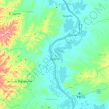
Name: Tenerife topographic map, elevation, terrain.
Location: Tenerife, Magdalena, RAP Caribe, 哥伦比亚 / 哥倫比亞 (9.80796 -74.87318 10.01783 -74.55403)
Average elevation: 68 m
Minimum elevation: 3 m
Maximum elevation: 361 m
Thank you for supporting this site ❤️
Make a donation
Make a donation
Gear up for your next adventure:
As an Amazon Associate, this site earns from qualifying purchases at no extra cost to you.