
Make a donation
Gear up for your next adventure:
As an Amazon Associate, this site earns from qualifying purchases at no extra cost to you.
Fitero topographic map
Click on the map to display elevation.
Make a donation
Gear up for your next adventure:
As an Amazon Associate, this site earns from qualifying purchases at no extra cost to you.
Fitero
The town of Fitero is located in the southwest of the Chartered Community of Navarra, within the geographical region knows as the Ribera de Navarra. It is located on the left bank of the Alhama river, and the town has an altitude of 421 meters above sea level. The municipal area covers 43.2 km2, and borders with Cintruenigo and Tudela, to the south, with Tarazona (Zaragoza), and to the west, with the municipalities of Cervera del Rio Alhama and Alfaro in the Community of La Rioja.
Make a donation
Gear up for your next adventure:
As an Amazon Associate, this site earns from qualifying purchases at no extra cost to you.
About this map
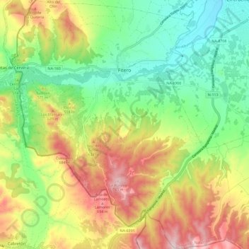
Name: Fitero topographic map, elevation, terrain.
Location: Fitero, Erribera / Ribera, Navarre, 31593, Spain (41.99474 -1.90848 42.07955 -1.82037)
Average elevation: 530 m
Minimum elevation: 380 m
Maximum elevation: 742 m
Make a donation
Gear up for your next adventure:
As an Amazon Associate, this site earns from qualifying purchases at no extra cost to you.