
Saarwellingen topographic map
Interactive map
Click on the map to display elevation.
About this map
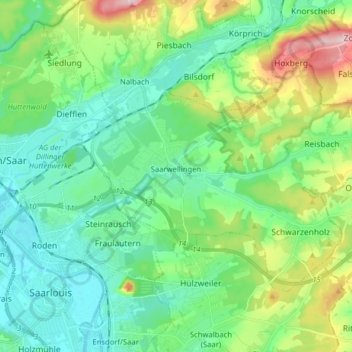
Name: Saarwellingen topographic map, elevation, terrain.
Location: Saarwellingen, Landkreis Saarlouis, Saarland, 66793, Germany (49.31680 6.76382 49.38441 6.92215)
Average elevation: 235 m
Minimum elevation: 173 m
Maximum elevation: 407 m
Other topographic maps
Click on a map to view its topography, its elevation and its terrain.
Schwalbach
Germany > Saarland > Landkreis Saarlouis
Schwalbach, Landkreis Saarlouis, Saarland, 66773, Germany
Average elevation: 236 m
Michelbach
Germany > Saarland > Landkreis Saarlouis
Michelbach, Schmelz, Landkreis Saarlouis, Saarland, 66839, Germany
Average elevation: 288 m
Saarlouis
Germany > Saarland > Landkreis Saarlouis > Saarlouis
Saarlouis, Landkreis Saarlouis, Saarland, 66740, Germany
Average elevation: 222 m