
Tarare topographic map
Interactive map
Click on the map to display elevation.
About this map
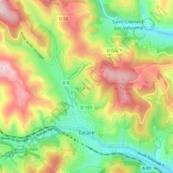
Name: Tarare topographic map, elevation, terrain.
Average elevation: 519 m
Minimum elevation: 351 m
Maximum elevation: 731 m
Other topographic maps
Click on a map to view its topography, its elevation and its terrain.
Parc Popy
France > Auvergne-Rhône-Alpes > Rhône > Belleville-en-Beaujolais > Le Petit Quart
Average elevation: 179 m
Port de Beauregard
France > Auvergne-Rhône-Alpes > Rhône > Villefranche-sur-Saône > Port de Beauregard
Average elevation: 191 m