Geolocate

Madhya topographic map

Click on the map to display elevation.

About this map

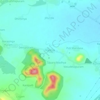
Name: Madhya topographic map, elevation, terrain.

Location: Madhya, Mandasa, Srikakulam, Andhra Pradesh, 532242, India (18.82843 84.44135 18.86843 84.48135)

Average elevation: 46 m

Minimum elevation: 23 m

Maximum elevation: 155 m

Gear up for your next adventure:

🧴Tick Removal Tools - Small, essential health tool for UK woodland and moorland
🌦️Portable Weather Meters - Handheld tools for monitoring weather conditions
🎒Multi-day Trekking Packs - Large capacity backpacks for wild camping and long-distance trails
🔋Lithium AA Batteries - Long-lasting power that performs well in cold mountain weather
Lightweight Tents - Compact tents for backpacking and trekking

As an Amazon Associate, this site earns from qualifying purchases at no extra cost to you.