
Make a donation
Gear up for your next adventure:
As an Amazon Associate, this site earns from qualifying purchases at no extra cost to you.
Ruidoso Downs topographic map
Click on the map to display elevation.
Make a donation
Gear up for your next adventure:
As an Amazon Associate, this site earns from qualifying purchases at no extra cost to you.
About this map
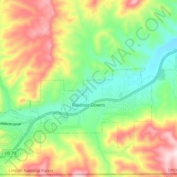
Name: Ruidoso Downs topographic map, elevation, terrain.
Location: Ruidoso Downs, Lincoln County, New Mexico, United States (33.31453 -105.62861 33.35511 -105.55545)
Average elevation: 2,091 m
Minimum elevation: 1,892 m
Maximum elevation: 2,369 m
Make a donation
Gear up for your next adventure:
As an Amazon Associate, this site earns from qualifying purchases at no extra cost to you.
Other topographic maps
Click on a map to view its topography, its elevation and its terrain.
Alto
United States > New Mexico > Lincoln County
Alto is located at an elevation of 7,550 feet (2,300 m) in the Lincoln National Forest, five miles (8.0 km) north of the village of Ruidoso. Alto received its name from the Spanish word "high" because of its elevation.
Average elevation: 2,285 m
Make a donation
Gear up for your next adventure:
As an Amazon Associate, this site earns from qualifying purchases at no extra cost to you.